Earthquake Banda Sea
Mon, 16 Feb 2026 10:07:06 GMT
Time3 days ago
Location
-6.9385, 129.8097
Depth
157.3 KM
Event Summary
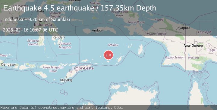
A 4.5 magnitude earthquake struck on Banda Sea, at Mon, 16 Feb 2026 10:07:06 GMT. Depth: 157.3486328125km. Reviewed by VYT seismologists, this light quake occurred at a magnitude type of earthquake.
Magnitude
4.5
earthquake
Source
VYT
Intensity
-
Agency Reports
2 Sources| Source | Magnitude | Depth | Time |
|---|---|---|---|
| VYTPrimary | 4.5 | 157 km | 3 days ago |
| BMKG | 4.8 | 174 km | 3 days ago |
Earthquake Details
AutomaticEvent IDvyt_3u6lhg7d4p3mo
Tsunami PotentialNo
Magnitude Typeearthquake
Nearest Places
- Damar Ridge36.1 km
- Nil Desperandum36.4 km
- Tanjung Sifanandrierna38.5 km
- Rumadai38.8 km
- Wotai39.6 km
Comments
Join the discussion about this event.
Latest Earthquakes
2.5Mag
Tarapaca, Chile
Time14 hours ago
Depth112.55 km
SourceVYT (Automatic)
2.3Mag
CENTRAL TURKEY
Time14 hours ago
Depth6.20 km
SourceAFAD (Automatic)
2.2Mag
Tarapaca, Chile
Time14 hours ago
Depth111.94 km
SourceVYT (Automatic)
1.9Mag
Central Alaska
Time14 hours ago
Depth32.10 km
SourceVYT (Automatic)
3.4Mag
HAWAII REGION, HAWAII
Time14 hours ago
Depth4.70 km
SourceHV (Automatic)
Nearby Earthquakes
4.1Mag
BANDA SEA
Time1 month ago
Depth184.00 km
SourceBMKG (Automatic)
5.0Mag
KEPULAUAN BABAR, INDONESIA
Time2 years ago
Depth120.00 km
SourceEMSC (Automatic)
4.0Mag
BANDA SEA
Time5 years ago
Depth108.00 km
SourceNEIC (Automatic)
5.4Mag
BANDA SEA
Time10 years ago
Depth100.00 km
SourceEMSC (Automatic)
6.8Mag
BANDA SEA
Time5 years ago
Depth99.00 km
SourceEMSC (Automatic)