Earthquake BANDA SEA
Thu, 08 Jan 2026 00:34:35 GMT
Time1 month ago
Location
-6.9700, 129.7900
Depth
184.0 KM
Event Summary
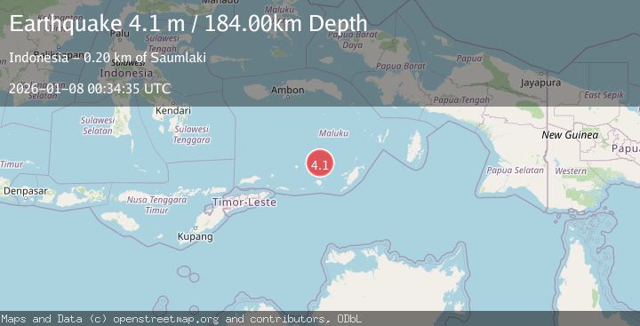
A 4.1 magnitude earthquake struck on BANDA SEA, at Thu, 08 Jan 2026 00:34:35 GMT. Depth: 184km. Reviewed by BMKG seismologists, this light quake occurred at a magnitude type of m.
Magnitude
4.1
m
Source
BMKG
Intensity
-
Agency Reports
1 Sources| Source | Magnitude | Depth | Time |
|---|---|---|---|
| BMKGPrimary | 4.1 | 184 km | 1 month ago |
Earthquake Details
AutomaticEvent IDemsc_BMKG_20260108_0000009
Tsunami PotentialNo
Magnitude Typem
Nearest Places
- Damar Ridge35.4 km
- Tanjung Sifanandrierna38.6 km
- Rumadai39.3 km
- Wotai39.7 km
- Nil Desperandum39.8 km
Comments
Join the discussion about this event.
Latest Earthquakes
2.4Mag
West Papua Region, Indonesia
Time10 minutes ago
Depth10.00 km
SourceBMKG
3.3Mag
Talaud Islands, Indonesia
Time11 minutes ago
Depth10.00 km
SourceBMKG
1.1Mag
4 km NW of The Geysers, CA
Time12 minutes ago
Depth3.39 km
SourceUSGS (Automatic)
1.0Mag
33 km WSW of Ackerly, Texas
Time12 minutes ago
Depth4.44 km
SourceUSGS (Automatic)
2.8Mag
Antofagasta, Chile
Time15 minutes ago
Depth0.00 km
SourceVYT (Automatic)
Nearby Earthquakes
4.5Mag
Banda Sea
Time3 days ago
Depth157.35 km
SourceVYT (Automatic)
5.0Mag
KEPULAUAN BABAR, INDONESIA
Time2 years ago
Depth120.00 km
SourceEMSC (Automatic)
4.5Mag
Banda Sea
Time2 days ago
Depth71.53 km
SourceVYT (Automatic)
4.6Mag
BANDA SEA
Time1 month ago
Depth138.00 km
SourceEMSC (Automatic)
4.0Mag
BANDA SEA
Time5 years ago
Depth108.00 km
SourceNEIC (Automatic)