Earthquake Southeastern Alaska
Thu, 19 Feb 2026 19:55:26 GMT
Time1 hour ago
Location
58.5501, -134.6769
Depth
6.3 KM
Event Summary
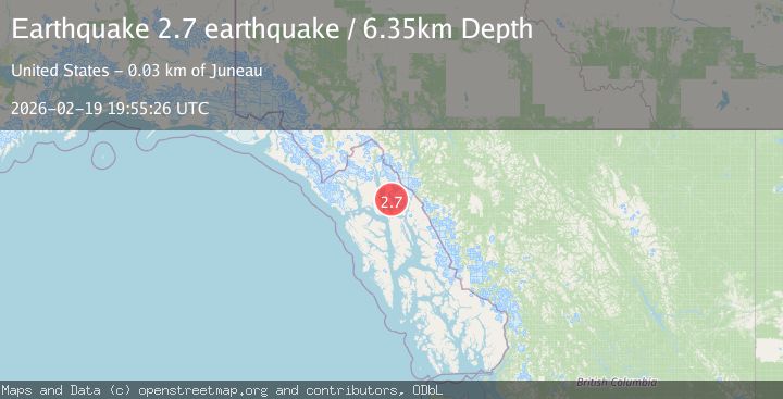
A 2.7 magnitude earthquake struck on Southeastern Alaska, at Thu, 19 Feb 2026 19:55:26 GMT. Depth: 6.34765625km. Reviewed by VYT seismologists, this minor quake occurred at a magnitude type of earthquake.
Magnitude
2.7
earthquake
Source
VYT
Intensity
-
Agency Reports
1 Sources| Source | Magnitude | Depth | Time |
|---|---|---|---|
| VYTPrimary | 2.7 | 6 km | 1 hour ago |
Earthquake Details
AutomaticEvent IDvyt_3uvko3g91a72i
Tsunami PotentialNo
Magnitude Typeearthquake
Nearest Places
- Mount Ernest Gruening2.6 km
- Windfall Creek5.5 km
- Windfall Lake5.6 km
- Boulder Creek6.1 km
- Eagle River Mine6.3 km
Comments
Join the discussion about this event.
Latest Earthquakes
1.8Mag
western Texas
Time53 minutes ago
Depth9.77 km
SourceVYT (Automatic)
0.8Mag
Southern Alaska
Time54 minutes ago
Depth5.62 km
SourceVYT (Automatic)
2.1Mag
Tarapaca, Chile
Time59 minutes ago
Depth0.24 km
SourceVYT (Automatic)
3.1Mag
OKLAHOMA
Time1 hour ago
Depth1.00 km
SourceOK (Automatic)
2.3Mag
western Texas
Time1 hour ago
Depth0.00 km
SourceVYT (Automatic)
Nearby Earthquakes
3.0Mag
SOUTHEASTERN ALASKA
Time4 years ago
Depth6.00 km
SourceNEIC (Automatic)
3.2Mag
Southeastern Alaska
Time1 week ago
Depth0.00 km
SourceVYT (Automatic)
3.0Mag
SOUTHEASTERN ALASKA
Time9 years ago
Depth1.00 km
SourceNEIC (Automatic)
3.0Mag
SOUTHEASTERN ALASKA
Time3 years ago
Depth10.00 km
SourceCN (Automatic)
3.0Mag
SOUTHEASTERN ALASKA
Time4 years ago
Depth5.00 km
SourceNEIC (Automatic)