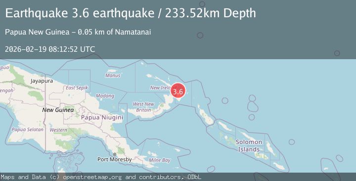
Earthquake New Ireland region, Papua New Guinea
Thu, 19 Feb 2026 08:12:52 GMT
Time2 months ago
Location
-3.8462, 152.8128
Depth
233.5 KM
Event Summary
A 3.6 magnitude earthquake struck on New Ireland region, Papua New Guinea, at Thu, 19 Feb 2026 08:12:52 GMT. Depth: 233.5205078125km. Reviewed by VYT seismologists, this minor quake occurred at a magnitude type of earthquake.
Magnitude
3.6
earthquake
Source
VYT
Intensity
-
Agency Reports
1 Sources| Source | Magnitude | Depth | Time |
|---|---|---|---|
| VYTPrimary | 3.6 | 234 km | 2 months ago |
Earthquake Details
AutomaticEvent IDvyt_6tqz2ylj0f4g
QualityA
Tsunami PotentialNo
Magnitude Typeearthquake
Last Update2 months ago
Total Stations51
Felt Reports0
Did you feel this earthquake? Report it to help others.
No reports yet
Be the first to report this earthquake!
Latest Earthquakes
Loading...
Nearby Earthquakes
4.8Mag
New Britain region, Papua New Guinea
Time8 hours ago
Depth48.46 km
SourceVYT (Automatic)
4.9Mag
New Ireland region, Papua New Guinea
Time19 hours ago
Depth10.00 km
SourceVYT (Automatic)
4.8Mag
NEW IRELAND REGION, P.N.G.
Time1 day ago
Depth10.00 km
SourceNEIC (Automatic)
4.8Mag
NEW IRELAND REGION, P.N.G.
Time1 week ago
Depth119.80 km
SourceNEIC (Automatic)
4.2Mag
NEW IRELAND REGION, P.N.G.
Time3 weeks ago
Depth115.30 km
SourceNEIC (Automatic)