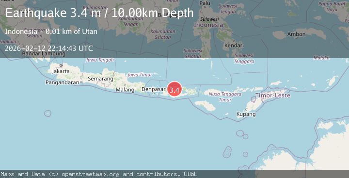
Earthquake Sumbawa region, Indonesia
Thu, 12 Feb 2026 22:14:43 GMT
Time6 days ago
Location
-8.3694, 117.1332
Depth
18.1 KM
Event Summary
A 3.4 magnitude earthquake struck on Sumbawa region, Indonesia, at Thu, 12 Feb 2026 22:14:43 GMT. Depth: 18.06640625km. Reviewed by VYT seismologists, this minor quake occurred at a magnitude type of earthquake.
Magnitude
3.4
earthquake
Source
VYT
Intensity
-
Agency Reports
2 Sources| Source | Magnitude | Depth | Time |
|---|---|---|---|
| VYTPrimary | 3.4 | 18 km | 6 days ago |
| BMKG | 3.4 | 10 km | 6 days ago |
Earthquake Details
AutomaticEvent IDvyt_miah5oqtu5p4
Tsunami PotentialNo
Magnitude Typeearthquake
Nearest Places
- Brang Utan0.6 km
- Enyong1.2 km
- Brang Ajengeng1.5 km
- Brang Semonte1.6 km
- Badang1.7 km
Comments
Join the discussion about this event.
Latest Earthquakes
4.5Mag
Central Alaska
Time2 minutes ago
Depth7.81 km
SourceVYT (Automatic)
1.9Mag
1 km SSW of Pāhala, Hawaii
Time5 minutes ago
Depth28.47 km
SourceUSGS (Automatic)
1.5Mag
5 km NW of The Geysers, CA
Time7 minutes ago
Depth2.47 km
SourceUSGS (Automatic)
0.3Mag
10 km WNW of The Geysers, CA
Time9 minutes ago
Depth2.50 km
SourceUSGS (Automatic)
2.5Mag
Central Alaska
Time10 minutes ago
Depth112.55 km
SourceVYT (Automatic)
Nearby Earthquakes
2.8Mag
Sumbawa region, Indonesia
Time1 week ago
Depth16.97 km
SourceVYT (Automatic)
2.0Mag
Sumbawa Region, Indonesia
Time4 days ago
Depth17.31 km
SourceBMKG
2.6Mag
Sumbawa Region, Indonesia
Time0 months ago
Depth11.02 km
SourceBMKG (Automatic)
2.2Mag
Sumbawa Region, Indonesia
Time3 weeks ago
Depth12.63 km
SourceBMKG (Automatic)
5.0Mag
SUMBAWA REGION, INDONESIA
Time12 years ago
Depth2.00 km
SourceEMSC (Automatic)