Earthquake Timor region, Indonesia
Wed, 25 Feb 2026 17:36:35 GMT
Time1 hour ago
Location
-8.2220, 127.0884
Depth
79.7 KM
Event Summary
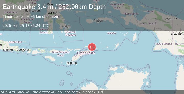
A 3.4 magnitude earthquake struck on Timor region, Indonesia, at Wed, 25 Feb 2026 17:36:35 GMT. Depth: 79.7119140625km. Reviewed by VYT seismologists, this minor quake occurred at a magnitude type of earthquake.
Magnitude
3.4
earthquake
Source
VYT
Intensity
-
Agency Reports
2 Sources| Source | Magnitude | Depth | Time |
|---|---|---|---|
| VYTPrimary | 2.7 | 80 km | 1 hour ago |
| BMKG | 3.4 | 252 km | 1 hour ago |
Earthquake Details
AutomaticEvent IDvyt_zvaqj0hzgjzm
Tsunami PotentialNo
Magnitude Typeearthquake
Nearest Places
- 14.0 km
- 14.0 km
- 14.1 km
- 14.2 km
- 14.2 km
Comments
Join the discussion about this event.
Latest Earthquakes
2.3Mag
Sunda Strait, Indonesia
Time45 minutes ago
Depth16.76 km
SourceBMKG
2.2Mag
western Texas
Time49 minutes ago
Depth0.00 km
SourceVYT (Automatic)
1.7Mag
19 km ESE of Johannesburg, CA
Time50 minutes ago
Depth3.35 km
SourceUSGS (Automatic)
3.0Mag
Southern Alaska
Time51 minutes ago
Depth20.63 km
SourceVYT (Automatic)
2.2Mag
SOUTHERN ITALY
Time53 minutes ago
Depth27.10 km
SourceINGV (Automatic)
Nearby Earthquakes
6.2Mag
EAST TIMOR REGION
Time3 years ago
Depth42.00 km
SourceEMSC (Automatic)
5.0Mag
EAST TIMOR REGION
Time19 years ago
Depth142.00 km
SourceEMSC (Automatic)
4.2Mag
Timor Region
Time2 weeks ago
Depth78.50 km
SourceBMKG (Automatic)
5.1Mag
EAST TIMOR REGION
Time13 years ago
Depth30.00 km
SourceEMSC (Automatic)
4.0Mag
EAST TIMOR REGION
Time4 years ago
Depth10.00 km
SourceDJA (Automatic)