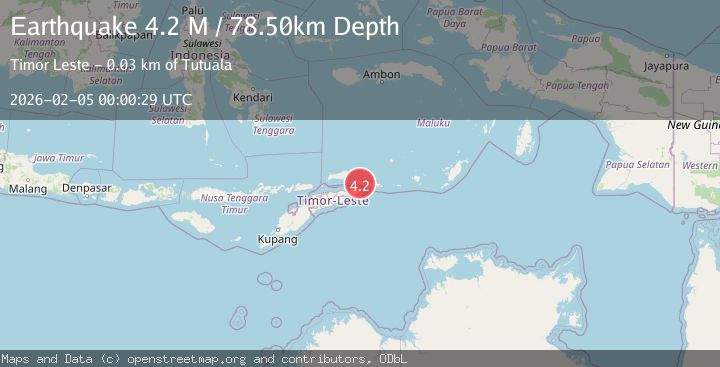
Earthquake Timor Region
Thu, 05 Feb 2026 00:00:29 GMT
Time10 hours ago
Location
-8.0055, 127.2268
Depth
82.5 KM
Event Summary
A 4.0 magnitude earthquake struck on Timor Region, at Thu, 05 Feb 2026 00:00:29 GMT. Depth: 82.533089km. Reviewed by BMKG seismologists, this minor quake occurred at a magnitude type of M.
Magnitude
4.0
M
Source
BMKG
Intensity
-
Agency Reports
1 Sources| Source | Magnitude | Depth | Time |
|---|---|---|---|
| BMKGPrimary | 4.0 | 83 km | 10 hours ago |
Earthquake Details
AutomaticEvent IDbmg2026clyq
Tsunami PotentialNo
Magnitude TypeM
Nearest Places
- Tanjung Asirloron3.2 km
- Tanjung Pura Pura3.5 km
- Desa Purpura5.0 km
- Desa Nomaha5.1 km
- Pantai Purapura5.2 km
Comments
Join the discussion about this event.
Latest Earthquakes
0.8Mag
6 km NW of The Geysers, CA
Time10 hours ago
Depth3.22 km
SourceUSGS (Automatic)
1.6Mag
8 km SSW of Ojai, CA
Time10 hours ago
Depth4.75 km
SourceUSGS (Automatic)
3.6Mag
South of Java, Indonesia
Time11 hours ago
Depth10.00 km
SourceBMKG (Automatic)
1.2Mag
WESTERN TURKEY
Time11 hours ago
Depth7.00 km
SourceAFAD (Automatic)
2.3Mag
South of Java, Indonesia
Time11 hours ago
Depth10.00 km
SourceBMKG (Automatic)
Nearby Earthquakes
3.7Mag
Banda Sea
Time1 week ago
Depth206.55 km
SourceBMKG (Automatic)
3.9Mag
Banda Sea
Time1 week ago
Depth117.78 km
SourceBMKG (Automatic)
5.6Mag
Banda Sea
Time1 week ago
Depth179.61 km
SourceBMKG (Automatic)
2.8Mag
Timor Region
Time3 days ago
Depth125.09 km
SourceBMKG (Automatic)
3.8Mag
KEPULAUAN BARAT DAYA, INDONESIA
Time1 week ago
Depth110.00 km
SourceBMKG (Automatic)