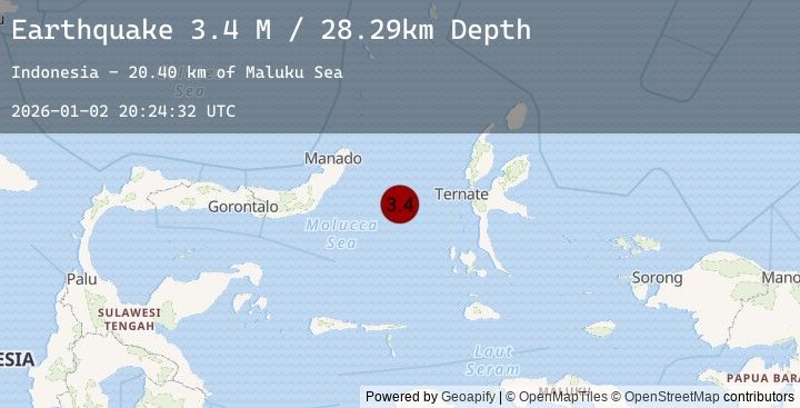
Earthquake Northern Molucca Sea
Fri, 02 Jan 2026 20:24:32 GMT
Time1 hour ago
Location
0.5809, 126.1645
Depth
28.3 KM
Event Summary
A 3.4 magnitude earthquake struck on Northern Molucca Sea, at Fri, 02 Jan 2026 20:24:32 GMT. Depth: 28.293249km. Reviewed by BMKG seismologists, this minor quake occurred at a magnitude type of M.
Magnitude
3.4
M
Source
BMKG
Intensity
-
Agency Reports
1 Sources| Source | Magnitude | Depth | Time |
|---|---|---|---|
| BMKGPrimary | 3.4 | 28 km | 1 hour ago |
Earthquake Details
AutomaticEvent IDbmg2026adjx
Tsunami PotentialNo
Magnitude TypeM
Nearest Places
- Maluku Sea20.4 km
- Kelurahan Tifure43.1 km
- Pulau Tifore43.7 km
- Kelurahan Pantai Sagu44.2 km
- Pulau Gureda45.2 km
Comments
Join the discussion about this event.
Latest Earthquakes
3.0Mag
SOUTHEASTERN ALASKA
Time1 hour ago
Depth0.30 km
SourceAK (Automatic)
2.8Mag
Southern Sumatra, Indonesia
Time1 hour ago
Depth26.20 km
SourceBMKG (Automatic)
2.0Mag
45 km S of Port Graham, Alaska
Time2 hours ago
Depth64.60 km
SourceUSGS (Automatic)
2.9Mag
South of Sumbawa, Indonesia
Time2 hours ago
Depth10.00 km
SourceBMKG (Automatic)
4.2Mag
66 km E of Nikolski, Alaska
Time2 hours ago
Depth16.80 km
SourceUSGS