Earthquake Northern Sumatra, Indonesia
Sat, 03 Jan 2026 23:58:41 GMT
Time3 days ago
Location
0.5231, 99.8935
Depth
138.2 KM
Event Summary
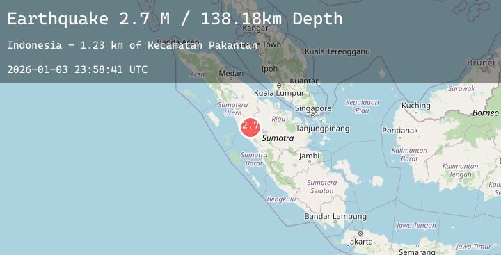
A 2.7 magnitude earthquake struck on Northern Sumatra, Indonesia, at Sat, 03 Jan 2026 23:58:41 GMT. Depth: 138.176422km. Reviewed by BMKG seismologists, this minor quake occurred at a magnitude type of M.
Magnitude
2.7
M
Source
BMKG
Intensity
-
Agency Reports
1 Sources| Source | Magnitude | Depth | Time |
|---|---|---|---|
| BMKGPrimary | 2.7 | 138 km | 3 days ago |
Earthquake Details
AutomaticEvent IDbmg2026afmm
Tsunami PotentialNo
Magnitude TypeM
Nearest Places
- Kecamatan Pakantan1.2 km
- Desa Huta Toras1.6 km
- Desa Huta Padang1.9 km
- Kototuo2.2 km
- Bukit Kubangan Barsahab2.5 km
Comments
Join the discussion about this event.
Latest Earthquakes
2.7Mag
Sulawesi, Indonesia
Time3 days ago
Depth5.00 km
SourceBMKG (Automatic)
2.7Mag
Java, Indonesia
Time3 days ago
Depth11.22 km
SourceBMKG (Automatic)
2.2Mag
67 km WNW of Happy Valley, Alaska
Time3 days ago
Depth128.90 km
SourceUSGS (Automatic)
2.2Mag
Java, Indonesia
Time3 days ago
Depth44.85 km
SourceBMKG (Automatic)
1.3Mag
9 km W of Templeton, CA
Time3 days ago
Depth5.82 km
SourceUSGS (Automatic)