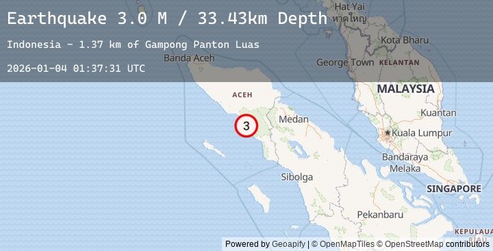
Earthquake Northern Sumatra, Indonesia
Sun, 04 Jan 2026 01:37:30 GMT
Time1 day ago
Location
3.3936, 97.0887
Depth
32.3 KM
Event Summary
A 3.0 magnitude earthquake struck on Northern Sumatra, Indonesia, at Sun, 04 Jan 2026 01:37:30 GMT. Depth: 32.278893km. Reviewed by BMKG seismologists, this minor quake occurred at a magnitude type of M.
Magnitude
3.0
M
Source
BMKG
Intensity
-
Agency Reports
1 Sources| Source | Magnitude | Depth | Time |
|---|---|---|---|
| BMKGPrimary | 3.0 | 32 km | 1 day ago |
Earthquake Details
AutomaticEvent IDbmg2026afps
Tsunami PotentialNo
Magnitude TypeM
Nearest Places
- Gampong Meuligo0.2 km
- Lhoktandilan0.7 km
- Alue Paku0.8 km
- Krueng Sikulat0.9 km
- Meuligo0.9 km
Comments
Join the discussion about this event.
Latest Earthquakes
1.9Mag
123 km SSW of McCarthy, Alaska
Time1 day ago
Depth0.20 km
SourceUSGS (Automatic)
1.3Mag
EASTERN TURKEY
Time1 day ago
Depth7.30 km
SourceAFAD (Automatic)
2.3Mag
South of Java, Indonesia
Time1 day ago
Depth21.81 km
SourceBMKG (Automatic)
2.1Mag
ISLAND OF HAWAII, HAWAII
Time1 day ago
Depth34.80 km
SourceHV (Automatic)
1.8Mag
121 km NW of Yakutat, Alaska
Time1 day ago
Depth12.10 km
SourceUSGS (Automatic)