Earthquake Southwest of Sumatra, Indonesia
Mon, 05 Jan 2026 22:59:30 GMT
Time4 days ago
Location
-6.3508, 103.3170
Depth
15.6 KM
Event Summary
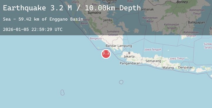
A 3.2 magnitude earthquake struck on Southwest of Sumatra, Indonesia, at Mon, 05 Jan 2026 22:59:30 GMT. Depth: 15.59657km. Reviewed by BMKG seismologists, this minor quake occurred at a magnitude type of M.
Magnitude
3.2
M
Source
BMKG
Intensity
-
Agency Reports
1 Sources| Source | Magnitude | Depth | Time |
|---|---|---|---|
| BMKGPrimary | 3.2 | 16 km | 4 days ago |
Earthquake Details
AutomaticEvent IDbmg2026ajbn
Tsunami PotentialNo
Magnitude TypeM
Nearest Places
- Enggano Basin61.8 km
- Tanjung Cuku Balimbing131.0 km
- Wai Tembuli133.3 km
- Desa Muara Tembulih134.1 km
- Wai Ngambur134.4 km
Comments
Join the discussion about this event.
Latest Earthquakes
3.4Mag
OFF E. COAST OF N. ISLAND, N.Z.
Time4 days ago
Depth33.00 km
SourceGNS (Automatic)
2.3Mag
53 km NW of Tatitlek, Alaska
Time4 days ago
Depth11.80 km
SourceUSGS (Automatic)
3.0Mag
Near North Coast of West Papua
Time4 days ago
Depth15.44 km
SourceBMKG (Automatic)
3.4Mag
NEAR S COAST OF PAPUA, INDONESIA
Time4 days ago
Depth97.00 km
SourceBMKG (Automatic)
3.1Mag
Seram, Indonesia
Time4 days ago
Depth9.85 km
SourceBMKG (Automatic)
Nearby Earthquakes
No significant earthquakes nearby recently.