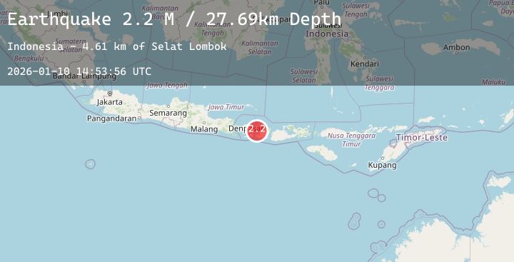
Earthquake Bali Region, Indonesia
Sat, 10 Jan 2026 14:53:56 GMT
Time1 day ago
Location
-8.4616, 115.8656
Depth
27.7 KM
Event Summary
A 2.0 magnitude earthquake struck on Bali Region, Indonesia, at Sat, 10 Jan 2026 14:53:56 GMT. Depth: 27.694921km. Reviewed by BMKG seismologists, this minor quake occurred at a magnitude type of M.
Magnitude
2.0
M
Source
BMKG
Intensity
-
Agency Reports
1 Sources| Source | Magnitude | Depth | Time |
|---|---|---|---|
| BMKGPrimary | 2.0 | 28 km | 1 day ago |
Earthquake Details
AutomaticEvent IDbmg2026arpa
Tsunami PotentialNo
Magnitude TypeM
Nearest Places
- Selat Lombok4.6 km
- Tanjung Karangasem14.4 km
- Gili Selang18.2 km
- Tanjung Bangle18.5 km
- Alang Alang Boutique Beach Resort18.6 km
Comments
Join the discussion about this event.
Latest Earthquakes
2.3Mag
Java, Indonesia
Time1 day ago
Depth194.47 km
SourceBMKG (Automatic)
2.9Mag
38 km E of Susitna North, Alaska
Time1 day ago
Depth27.50 km
SourceUSGS (Automatic)
4.0Mag
OFFSHORE ATACAMA, CHILE
Time1 day ago
Depth55.20 km
SourceCSN (Automatic)
3.2Mag
OFF E. COAST OF N. ISLAND, N.Z.
Time1 day ago
Depth10.10 km
SourceGNS (Automatic)
4.8Mag
OFF EAST COAST OF KAMCHATKA
Time1 day ago
Depth27.90 km
SourceNEIC (Automatic)