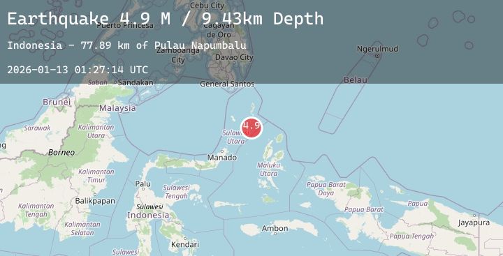
Earthquake Northern Molucca Sea
Tue, 13 Jan 2026 01:27:16 GMT
Time1 hour ago
Location
2.9800, 126.7051
Depth
30.6 KM
Event Summary
A 5.1 magnitude earthquake struck on Northern Molucca Sea, at Tue, 13 Jan 2026 01:27:16 GMT. Depth: 30.555609km. Reviewed by BMKG seismologists, this moderate quake occurred at a magnitude type of M.
Magnitude
5.1
M
Source
BMKG
Intensity
-
Agency Reports
2 Sources| Source | Magnitude | Depth | Time |
|---|---|---|---|
| BMKGPrimary | 4.9 | 31 km | 1 hour ago |
| EMSC | 5.1 | 51 km | 1 hour ago |
Earthquake Details
AutomaticEvent IDbmg2026awax
Tsunami PotentialNo
Magnitude TypeM
Nearest Places
- Pulau Napumbalu75.3 km
- Tanjung Pallo84.3 km
- Taduwale85.2 km
- Peret85.6 km
- Tanjung Panii85.6 km
Comments
Join the discussion about this event.
Latest Earthquakes
3.5Mag
NEAR S. COAST OF HONSHU, JAPAN
Time1 hour ago
Depth40.00 km
SourceJMA (Automatic)
4.7Mag
Southern Sumatra, Indonesia
Time1 hour ago
Depth10.88 km
SourceBMKG (Automatic)
2.9Mag
Java, Indonesia
Time1 hour ago
Depth36.00 km
SourceBMKG (Automatic)
0.8Mag
9 km NW of The Geysers, CA
Time1 hour ago
Depth2.20 km
SourceUSGS (Automatic)
3.6Mag
Timor Region
Time1 hour ago
Depth29.26 km
SourceBMKG (Automatic)