Earthquake West Papua, Indonesia
Tue, 13 Jan 2026 01:40:27 GMT
Time2 hours ago
Location
-3.0887, 139.6141
Depth
14.8 KM
Event Summary
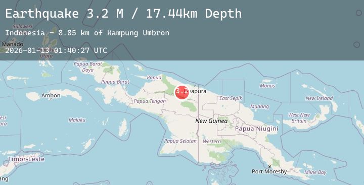
A 3.3 magnitude earthquake struck on West Papua, Indonesia, at Tue, 13 Jan 2026 01:40:27 GMT. Depth: 14.846497km. Reviewed by BMKG seismologists, this minor quake occurred at a magnitude type of M.
Magnitude
3.3
M
Source
BMKG
Intensity
-
Agency Reports
1 Sources| Source | Magnitude | Depth | Time |
|---|---|---|---|
| BMKGPrimary | 3.3 | 15 km | 2 hours ago |
Earthquake Details
AutomaticEvent IDbmg2026awbj
Tsunami PotentialNo
Magnitude TypeM
Nearest Places
- Kampung Umbron6.4 km
- Barito17.1 km
- Kampung Tetom18.7 km
- Kampung Kiren22.2 km
- Abo28.1 km
Comments
Join the discussion about this event.
Latest Earthquakes
2.2Mag
WESTERN TEXAS
Time2 hours ago
Depth4.70 km
SourceTX (Automatic)
2.3Mag
Sumbawa Region, Indonesia
Time2 hours ago
Depth24.94 km
SourceBMKG (Automatic)
3.7Mag
CYPRUS REGION
Time2 hours ago
Depth10.00 km
SourceAFAD (Automatic)
5.2Mag
Northern Molucca Sea
Time2 hours ago
Depth30.56 km
SourceBMKG (Automatic)
3.5Mag
NEAR S. COAST OF HONSHU, JAPAN
Time2 hours ago
Depth40.00 km
SourceJMA (Automatic)