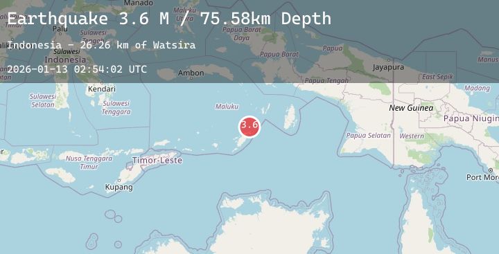
Earthquake Tanimbar Islands Region, Indonesia
Tue, 13 Jan 2026 02:54:01 GMT
Time2 hours ago
Location
-6.7836, 131.7752
Depth
86.4 KM
Event Summary
A 3.1 magnitude earthquake struck on Tanimbar Islands Region, Indonesia, at Tue, 13 Jan 2026 02:54:01 GMT. Depth: 86.390152km. Reviewed by BMKG seismologists, this minor quake occurred at a magnitude type of M.
Magnitude
3.1
M
Source
BMKG
Intensity
-
Agency Reports
1 Sources| Source | Magnitude | Depth | Time |
|---|---|---|---|
| BMKGPrimary | 3.1 | 86 km | 2 hours ago |
Earthquake Details
AutomaticEvent IDbmg2026awdu
Tsunami PotentialNo
Magnitude TypeM
Nearest Places
- Tanjung Larumat20.3 km
- Kilun21.1 km
- Tanjung Habamuri21.6 km
- Kelyobarwahan21.6 km
- Desa Wadankou21.7 km
Comments
Join the discussion about this event.
Latest Earthquakes
1.6Mag
3 km SSW of Dublin, CA
Time1 hour ago
Depth14.26 km
SourceUSGS (Automatic)
2.4Mag
AZORES ISLANDS, PORTUGAL
Time2 hours ago
Depth0.90 km
SourcePDA (Automatic)
1.0Mag
10 km SSW of Toms Place, CA
Time2 hours ago
Depth2.41 km
SourceUSGS (Automatic)
4.2Mag
PERU-ECUADOR BORDER REGION
Time2 hours ago
Depth35.00 km
SourceLIM (Automatic)
1.4Mag
91 km WNW of Karluk, Alaska
Time2 hours ago
Depth75.40 km
SourceUSGS (Automatic)
Nearby Earthquakes
No significant earthquakes nearby recently.