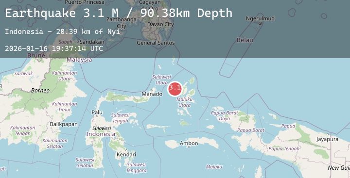
Earthquake Northern Molucca Sea
Fri, 16 Jan 2026 19:37:13 GMT
Time4 hours ago
Location
1.6009, 126.8612
Depth
97.2 KM
Event Summary
A 3.3 magnitude earthquake struck on Northern Molucca Sea, at Fri, 16 Jan 2026 19:37:13 GMT. Depth: 97.224365km. Reviewed by BMKG seismologists, this minor quake occurred at a magnitude type of M.
Magnitude
3.3
M
Source
BMKG
Intensity
-
Agency Reports
2 Sources| Source | Magnitude | Depth | Time |
|---|---|---|---|
| BMKGPrimary | 3.3 | 97 km | 4 hours ago |
| BMKGPrimary | 3.1 | 90 km | 4 hours ago |
Earthquake Details
AutomaticEvent IDbmg2026bcxj
Tsunami PotentialNo
Magnitude TypeM
Nearest Places
- Nyi26.4 km
- Kelurahan Bido59.3 km
- Pulau Mayu61.0 km
- Kecamatan Pulau Batang Dua61.2 km
- Kelurahan Mayau61.5 km
Comments
Join the discussion about this event.
Latest Earthquakes
1.4Mag
9 km S of Bakersfield, CA
Time4 hours ago
Depth25.30 km
SourceUSGS (Automatic)
5.2Mag
HOKKAIDO, JAPAN REGION
Time4 hours ago
Depth40.00 km
SourceEMSC (Automatic)
2.4Mag
Sulawesi, Indonesia
Time4 hours ago
Depth5.00 km
SourceBMKG (Automatic)
2.0Mag
Sulawesi, Indonesia
Time5 hours ago
Depth3.15 km
SourceBMKG (Automatic)
2.8Mag
Java, Indonesia
Time5 hours ago
Depth109.86 km
SourceBMKG (Automatic)
Nearby Earthquakes
3.2Mag
Northern Molucca Sea
Time8 hours ago
Depth64.49 km
SourceBMKG (Automatic)
3.2Mag
Halmahera, Indonesia
Time11 hours ago
Depth111.95 km
SourceBMKG (Automatic)
3.4Mag
Northern Molucca Sea
Time13 hours ago
Depth32.71 km
SourceBMKG (Automatic)
3.1Mag
Northern Molucca Sea
Time17 hours ago
Depth109.28 km
SourceBMKG (Automatic)
5.1Mag
Halmahera, Indonesia
Time1 day ago
Depth99.09 km
SourceBMKG (Automatic)