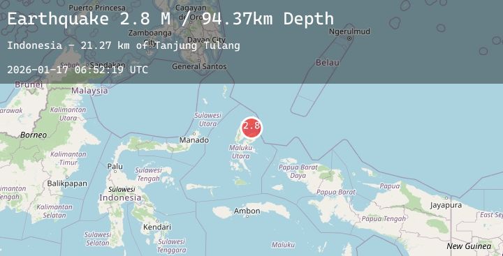
Earthquake Northern Molucca Sea
Sat, 17 Jan 2026 06:52:15 GMT
Time2 hours ago
Location
2.0168, 127.6571
Depth
110.4 KM
Event Summary
A 3.0 magnitude earthquake struck on Northern Molucca Sea, at Sat, 17 Jan 2026 06:52:15 GMT. Depth: 110.385689km. Reviewed by BMKG seismologists, this minor quake occurred at a magnitude type of M.
Magnitude
3.0
M
Source
BMKG
Intensity
-
Agency Reports
1 Sources| Source | Magnitude | Depth | Time |
|---|---|---|---|
| BMKGPrimary | 3.0 | 110 km | 2 hours ago |
Earthquake Details
AutomaticEvent IDbmg2026bdtq
Tsunami PotentialNo
Magnitude TypeM
Nearest Places
- Pulau Diti9.7 km
- Pulau Togerebongo10.0 km
- Ake Boro10.1 km
- Baja10.3 km
- Tanjung Gogusulok10.3 km
Comments
Join the discussion about this event.
Latest Earthquakes
2.1Mag
NORTHERN CALIFORNIA
Time1 hour ago
Depth3.10 km
SourceNC (Automatic)
5.3Mag
OFF EAST COAST OF KAMCHATKA
Time2 hours ago
Depth23.10 km
SourceNEIC (Automatic)
1.5Mag
35 km WSW of Ackerly, Texas
Time2 hours ago
Depth4.83 km
SourceUSGS (Automatic)
1.1Mag
6 km NNW of The Geysers, CA
Time2 hours ago
Depth1.87 km
SourceUSGS (Automatic)
2.4Mag
WESTERN TEXAS
Time2 hours ago
Depth6.90 km
SourceTX (Automatic)
Nearby Earthquakes
3.1Mag
Halmahera, Indonesia
Time3 hours ago
Depth7.07 km
SourceBMKG (Automatic)
2.4Mag
Halmahera, Indonesia
Time9 hours ago
Depth25.65 km
SourceBMKG (Automatic)
3.3Mag
Northern Molucca Sea
Time13 hours ago
Depth97.22 km
SourceBMKG (Automatic)
3.2Mag
Halmahera, Indonesia
Time20 hours ago
Depth111.95 km
SourceBMKG (Automatic)