Earthquake Northern Sumatra, Indonesia
Sat, 17 Jan 2026 18:07:51 GMT
Time2 hours ago
Location
4.0751, 97.4554
Depth
4.3 KM
Event Summary
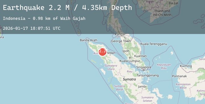
A 2.2 magnitude earthquake struck on Northern Sumatra, Indonesia, at Sat, 17 Jan 2026 18:07:51 GMT. Depth: 4.345609km. Reviewed by BMKG seismologists, this minor quake occurred at a magnitude type of M.
Magnitude
2.2
M
Source
BMKG
Intensity
-
Agency Reports
1 Sources| Source | Magnitude | Depth | Time |
|---|---|---|---|
| BMKGPrimary | 2.2 | 4 km | 2 hours ago |
Earthquake Details
AutomaticEvent IDbmg2026bepy
Tsunami PotentialNo
Magnitude TypeM
Nearest Places
- Waih Gajah1.0 km
- Oreng1.5 km
- Waih Uring2.0 km
- Gajah2.8 km
- Gampong Uring3.2 km
Comments
Join the discussion about this event.
Latest Earthquakes
1.8Mag
16 km S of Volcano, Hawaii
Time2 hours ago
Depth0.45 km
SourceUSGS (Automatic)
2.5Mag
CENTRAL TURKEY
Time2 hours ago
Depth6.20 km
SourceEMSC (Automatic)
3.6Mag
GREENLAND SEA
Time2 hours ago
Depth4.70 km
SourceNORSAR (Automatic)
3.1Mag
Seram, Indonesia
Time2 hours ago
Depth65.33 km
SourceBMKG (Automatic)
2.4Mag
18 km NW of Girdwood, Alaska
Time2 hours ago
Depth17.30 km
SourceUSGS (Automatic)