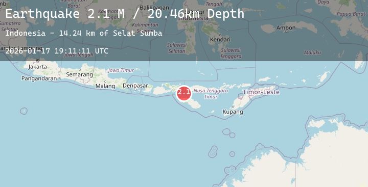
Earthquake Sumba Region, Indonesia
Sat, 17 Jan 2026 19:11:10 GMT
Time4 hours ago
Location
-9.0181, 119.3607
Depth
10.0 KM
Event Summary
A 2.2 magnitude earthquake struck on Sumba Region, Indonesia, at Sat, 17 Jan 2026 19:11:10 GMT. Depth: 10km. Reviewed by BMKG seismologists, this minor quake occurred at a magnitude type of M.
Magnitude
2.2
M
Source
BMKG
Intensity
-
Agency Reports
1 Sources| Source | Magnitude | Depth | Time |
|---|---|---|---|
| BMKGPrimary | 2.2 | 10 km | 4 hours ago |
Earthquake Details
AutomaticEvent IDbmg2026besb
Tsunami PotentialNo
Magnitude TypeM
Nearest Places
- Selat Sumba12.3 km
- Pulau Tala29.1 km
- Pulau Langkoi31.2 km
- Toro Langkoi31.2 km
- Nusa Duawaju31.6 km
Comments
Join the discussion about this event.
Latest Earthquakes
1.0Mag
NORTHERN ITALY
Time4 hours ago
Depth6.00 km
SourceOGS (Automatic)
2.0Mag
Sumbawa Region, Indonesia
Time4 hours ago
Depth15.30 km
SourceBMKG (Automatic)
4.1Mag
COSTA RICA
Time5 hours ago
Depth41.00 km
SourceUNA (Automatic)
2.5Mag
Sulawesi, Indonesia
Time5 hours ago
Depth5.00 km
SourceBMKG (Automatic)
3.7Mag
EASTERN HONSHU, JAPAN
Time5 hours ago
Depth10.00 km
SourceJMA (Automatic)