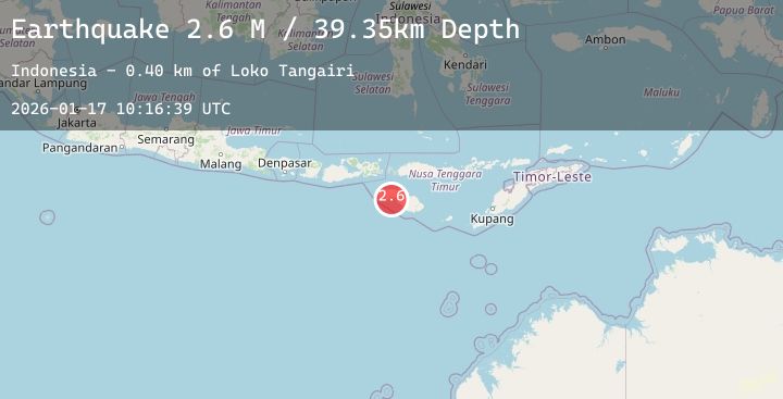
Earthquake Sumba Region, Indonesia
Sat, 17 Jan 2026 10:16:39 GMT
Time1 hour ago
Location
-9.7375, 119.5786
Depth
43.6 KM
Event Summary
A 2.9 magnitude earthquake struck on Sumba Region, Indonesia, at Sat, 17 Jan 2026 10:16:39 GMT. Depth: 43.647476km. Reviewed by BMKG seismologists, this minor quake occurred at a magnitude type of M.
Magnitude
2.9
M
Source
BMKG
Intensity
-
Agency Reports
2 Sources| Source | Magnitude | Depth | Time |
|---|---|---|---|
| BMKGPrimary | 2.9 | 44 km | 1 hour ago |
| BMKGPrimary | 2.6 | 39 km | 1 hour ago |
Earthquake Details
AutomaticEvent IDbmg2026beak
Tsunami PotentialNo
Magnitude TypeM
Nearest Places
- Palindi Wuludawu1.2 km
- Palindi Surujela1.9 km
- Loko Lisi2.8 km
- Teluk Lisi3.0 km
- Loko Hedikari3.1 km
Comments
Join the discussion about this event.
Latest Earthquakes
1.0Mag
23 km W of Skwentna, Alaska
Time1 hour ago
Depth93.90 km
SourceUSGS (Automatic)
2.7Mag
Timor Region
Time1 hour ago
Depth63.53 km
SourceBMKG (Automatic)
1.6Mag
40 km NW of Valdez, Alaska
Time2 hours ago
Depth23.30 km
SourceUSGS (Automatic)
1.4Mag
7 km NW of The Geysers, CA
Time2 hours ago
Depth0.99 km
SourceUSGS (Automatic)
3.6Mag
CENTRAL ALASKA
Time2 hours ago
Depth0.00 km
SourceAK (Automatic)