Earthquake Flores Region, Indonesia
Sat, 17 Jan 2026 12:46:06 GMT
Time1 hour ago
Location
-8.9558, 119.1509
Depth
8.8 KM
Event Summary
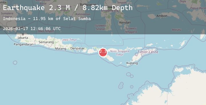
A 2.3 magnitude earthquake struck on Flores Region, Indonesia, at Sat, 17 Jan 2026 12:46:06 GMT. Depth: 8.817415km. Reviewed by BMKG seismologists, this minor quake occurred at a magnitude type of M.
Magnitude
2.3
M
Source
BMKG
Intensity
-
Agency Reports
1 Sources| Source | Magnitude | Depth | Time |
|---|---|---|---|
| BMKGPrimary | 2.3 | 9 km | 1 hour ago |
Earthquake Details
AutomaticEvent IDbmg2026befi
Tsunami PotentialNo
Magnitude TypeM
Nearest Places
- Selat Sumba11.9 km
- Toro Rata22.8 km
- Tano Nggelu23.2 km
- Lutu Tinam23.4 km
- Toro Bebula25.9 km
Comments
Join the discussion about this event.
Latest Earthquakes
2.4Mag
Northern Sumatra, Indonesia
Time2 hours ago
Depth3.00 km
SourceBMKG (Automatic)
4.1Mag
SOUTHWESTERN RYUKYU ISL., JAPAN
Time2 hours ago
Depth20.00 km
SourceJMA (Automatic)
1.8Mag
126 km SSE of McCarthy, Alaska
Time2 hours ago
Depth6.10 km
SourceUSGS (Automatic)
2.1Mag
58 km SSE of King Salmon, Alaska
Time2 hours ago
Depth7.50 km
SourceUSGS (Automatic)
2.5Mag
South of Bali, Indonesia
Time2 hours ago
Depth31.57 km
SourceBMKG (Automatic)