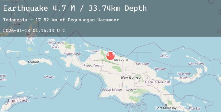
Earthquake Near North Coast of West Papua
Sun, 18 Jan 2026 01:15:14 GMT
Time2 hours ago
Location
-2.5518, 139.3476
Depth
35.7 KM
Event Summary
A 5.0 magnitude earthquake struck on Near North Coast of West Papua, at Sun, 18 Jan 2026 01:15:14 GMT. Depth: 35.658543km. Reviewed by BMKG seismologists, this moderate quake occurred at a magnitude type of M.
Magnitude
5.0
M
Source
BMKG
Intensity
-
Agency Reports
3 Sources| Source | Magnitude | Depth | Time |
|---|---|---|---|
| BMKGPrimary | 5.0 | 36 km | 2 hours ago |
| NEIC | 4.9 | 24 km | 2 hours ago |
| USGS | 4.9 | 24 km | 2 hours ago |
Earthquake Details
AutomaticEvent IDbmg2026bfea
Tsunami PotentialNo
Magnitude TypeM
Nearest Places
- Provinsi Papua8.7 km
- Pegunungan Karamoor12.5 km
- Titiwaifuru16.7 km
- Air Wages17.8 km
- Sonsar20.7 km
Comments
Join the discussion about this event.
Latest Earthquakes
2.1Mag
Minahassa Peninsula, Sulawesi
Time8 minutes ago
Depth59.26 km
SourceBMKG (Automatic)
1.5Mag
11 km N of Karnes City, Texas
Time10 minutes ago
Depth10.83 km
SourceUSGS (Automatic)
1.7Mag
1 km WSW of Brawley, CA
Time26 minutes ago
Depth9.35 km
SourceUSGS (Automatic)
2.2Mag
Flores Sea
Time29 minutes ago
Depth10.00 km
SourceBMKG (Automatic)
4.2Mag
SOUTHERN ALASKA
Time31 minutes ago
Depth65.00 km
SourceNEIC (Automatic)