Earthquake Flores Region, Indonesia
Mon, 26 Jan 2026 12:12:23 GMT
Time1 day ago
Location
-8.9462, 123.9616
Depth
7.0 KM
Event Summary
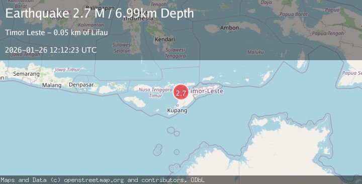
A 2.7 magnitude earthquake struck on Flores Region, Indonesia, at Mon, 26 Jan 2026 12:12:23 GMT. Depth: 6.992659km. Reviewed by BMKG seismologists, this minor quake occurred at a magnitude type of M.
Magnitude
2.7
M
Source
BMKG
Intensity
-
Agency Reports
1 Sources| Source | Magnitude | Depth | Time |
|---|---|---|---|
| BMKGPrimary | 2.7 | 7 km | 1 day ago |
Earthquake Details
AutomaticEvent IDbmg2026bupt
Tsunami PotentialNo
Magnitude TypeM
Nearest Places
- Pulau Batek35.7 km
- Point Panamtasa41.9 km
- River Oenis42.0 km
- River Namun42.4 km
- River Niutmieo42.8 km
Comments
Join the discussion about this event.
Latest Earthquakes
2.0Mag
Sumbawa Region, Indonesia
Time6 minutes ago
Depth107.77 km
SourceBMKG (Automatic)
1.7Mag
26 km WNW of Ludlow, CA
Time10 minutes ago
Depth1.36 km
SourceUSGS (Automatic)
3.1Mag
HAITI REGION
Time13 minutes ago
Depth7.00 km
SourceAYIT (Automatic)
2.6Mag
PUERTO RICO
Time19 minutes ago
Depth16.10 km
SourcePR (Automatic)
2.1Mag
WESTERN TEXAS
Time30 minutes ago
Depth4.40 km
SourceTX (Automatic)
Nearby Earthquakes
3.2Mag
Flores Region, Indonesia
Time6 days ago
Depth82.44 km
SourceBMKG (Automatic)
2.5Mag
Flores Region, Indonesia
Time6 days ago
Depth51.05 km
SourceBMKG (Automatic)
3.1Mag
Flores Region, Indonesia
Time3 days ago
Depth70.54 km
SourceBMKG (Automatic)
2.6Mag
Timor Region
Time2 days ago
Depth83.16 km
SourceBMKG (Automatic)
3.3Mag
Timor Region
Time1 day ago
Depth47.49 km
SourceBMKG (Automatic)