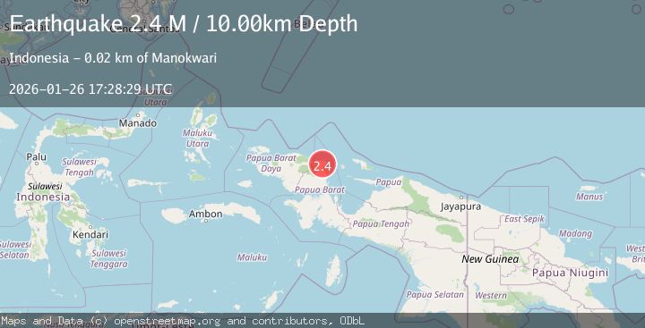
Earthquake West Papua Region, Indonesia
Mon, 26 Jan 2026 17:28:28 GMT
Time18 hours ago
Location
-0.8985, 133.9211
Depth
10.0 KM
Event Summary
A 2.3 magnitude earthquake struck on West Papua Region, Indonesia, at Mon, 26 Jan 2026 17:28:28 GMT. Depth: 10km. Reviewed by BMKG seismologists, this minor quake occurred at a magnitude type of M.
Magnitude
2.3
M
Source
BMKG
Intensity
-
Agency Reports
1 Sources| Source | Magnitude | Depth | Time |
|---|---|---|---|
| BMKGPrimary | 2.3 | 10 km | 18 hours ago |
Earthquake Details
AutomaticEvent IDbmg2026bvae
Tsunami PotentialNo
Magnitude TypeM
Nearest Places
- Kampung Ingkwoisi2.1 km
- Kampung Bedip Matoa2.3 km
- Kampung Somi3.4 km
- Kampung Wasai3.5 km
- Kampung Mebji3.8 km
Comments
Join the discussion about this event.
Latest Earthquakes
0.9Mag
23 km SW of Snyder, Texas
Time18 hours ago
Depth3.41 km
SourceUSGS (Automatic)
2.4Mag
ADRIATIC SEA
Time18 hours ago
Depth15.00 km
SourceIGEO (Automatic)
5.8Mag
New Guinea, Papua New Guinea
Time19 hours ago
Depth122.44 km
SourceBMKG (Automatic)
3.8Mag
ANTOFAGASTA, CHILE
Time19 hours ago
Depth107.00 km
SourceCSN (Automatic)
2.0Mag
ISLAND OF HAWAII, HAWAII
Time19 hours ago
Depth30.30 km
SourceHV (Automatic)
Nearby Earthquakes
3.2Mag
West Papua Region, Indonesia
Time3 days ago
Depth21.74 km
SourceBMKG (Automatic)
2.1Mag
West Papua Region, Indonesia
Time5 days ago
Depth38.83 km
SourceBMKG (Automatic)
2.5Mag
West Papua Region, Indonesia
Time3 days ago
Depth12.18 km
SourceBMKG (Automatic)
2.8Mag
West Papua Region, Indonesia
Time2 days ago
Depth10.00 km
SourceBMKG (Automatic)
2.1Mag
West Papua Region, Indonesia
Time3 days ago
Depth14.74 km
SourceBMKG (Automatic)