Earthquake West Papua Region, Indonesia
Thu, 22 Jan 2026 07:05:06 GMT
Time5 days ago
Location
-1.0545, 133.6420
Depth
38.8 KM
Event Summary
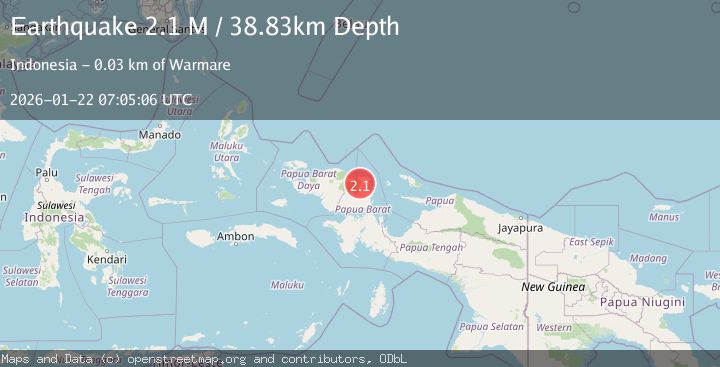
A 2.1 magnitude earthquake struck on West Papua Region, Indonesia, at Thu, 22 Jan 2026 07:05:06 GMT. Depth: 38.829571km. Reviewed by BMKG seismologists, this minor quake occurred at a magnitude type of M.
Magnitude
2.1
M
Source
BMKG
Intensity
-
Agency Reports
1 Sources| Source | Magnitude | Depth | Time |
|---|---|---|---|
| BMKGPrimary | 2.1 | 39 km | 5 days ago |
Earthquake Details
AutomaticEvent IDbmg2026bmxp
Tsunami PotentialNo
Magnitude TypeM
Nearest Places
- Kampung Waramui6.9 km
- Warmomi7.0 km
- Gunung Itsjwei7.8 km
- Pegunungan Memendes11.8 km
- Kampung Aska11.9 km
Comments
Join the discussion about this event.
Latest Earthquakes
2.1Mag
WESTERN TEXAS
Time20 minutes ago
Depth4.40 km
SourceTX (Automatic)
1.3Mag
20 km ENE of Little Lake, CA
Time20 minutes ago
Depth1.84 km
SourceUSGS (Automatic)
2.9Mag
South of Java, Indonesia
Time27 minutes ago
Depth3.21 km
SourceBMKG (Automatic)
2.0Mag
WESTERN TURKEY
Time28 minutes ago
Depth6.70 km
SourceAFAD (Automatic)
2.1Mag
6 km NNW of The Geysers, CA
Time38 minutes ago
Depth2.52 km
SourceUSGS (Automatic)
Nearby Earthquakes
2.4Mag
West Papua Region, Indonesia
Time20 hours ago
Depth10.00 km
SourceBMKG (Automatic)
3.2Mag
West Papua Region, Indonesia
Time3 days ago
Depth21.74 km
SourceBMKG (Automatic)
2.5Mag
West Papua Region, Indonesia
Time3 days ago
Depth12.18 km
SourceBMKG (Automatic)
2.4Mag
West Papua Region, Indonesia
Time1 day ago
Depth10.00 km
SourceBMKG (Automatic)
2.1Mag
West Papua Region, Indonesia
Time3 days ago
Depth14.74 km
SourceBMKG (Automatic)