Earthquake West Papua Region, Indonesia
Tue, 27 Jan 2026 03:35:36 GMT
Time3 hours ago
Location
-3.4012, 131.1023
Depth
83.9 KM
Event Summary
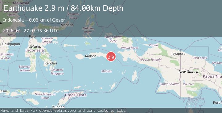
A 2.9 magnitude earthquake struck on West Papua Region, Indonesia, at Tue, 27 Jan 2026 03:35:36 GMT. Depth: 83.856003km. Reviewed by BMKG seismologists, this minor quake occurred at a magnitude type of M.
Magnitude
2.9
M
Source
BMKG
Intensity
-
Agency Reports
1 Sources| Source | Magnitude | Depth | Time |
|---|---|---|---|
| BMKGPrimary | 2.9 | 84 km | 3 hours ago |
Earthquake Details
AutomaticEvent IDbmg2026bvue
Tsunami PotentialNo
Magnitude TypeM
Nearest Places
- Pulau Madorang27.2 km
- Karang Urlah28.7 km
- Pulau Akat29.3 km
- Karang Ulin29.6 km
- Pulau Akat30.0 km
Comments
Join the discussion about this event.
Latest Earthquakes
1.3Mag
24 km NNW of Westbrook, Texas
Time3 hours ago
Depth3.71 km
SourceUSGS (Automatic)
2.2Mag
BAJA CALIFORNIA, MEXICO
Time3 hours ago
Depth1.20 km
SourceSCSN (Automatic)
3.4Mag
ATACAMA, CHILE
Time4 hours ago
Depth24.80 km
SourceCSN (Automatic)
1.7Mag
3 km NE of Oakland, CA
Time4 hours ago
Depth8.73 km
SourceUSGS (Automatic)
2.0Mag
35 km SSE of Denali National Park, Alaska
Time4 hours ago
Depth0.10 km
SourceUSGS (Automatic)
Nearby Earthquakes
2.2Mag
Seram, Indonesia
Time5 days ago
Depth10.00 km
SourceBMKG (Automatic)
2.6Mag
West Papua Region, Indonesia
Time4 days ago
Depth62.78 km
SourceBMKG (Automatic)
2.6Mag
Seram, Indonesia
Time1 day ago
Depth9.93 km
SourceBMKG (Automatic)
3.6Mag
Banda Sea
Time5 days ago
Depth132.89 km
SourceBMKG (Automatic)
3.2Mag
Banda Sea
Time1 day ago
Depth172.05 km
SourceBMKG (Automatic)