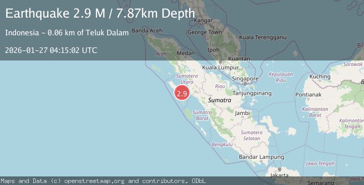
Earthquake Northern Sumatra, Indonesia
Tue, 27 Jan 2026 04:15:02 GMT
Time8 hours ago
Location
0.5207, 98.3638
Depth
7.9 KM
Event Summary
A 2.9 magnitude earthquake struck on Northern Sumatra, Indonesia, at Tue, 27 Jan 2026 04:15:02 GMT. Depth: 7.870379km. Reviewed by BMKG seismologists, this minor quake occurred at a magnitude type of M.
Magnitude
2.9
M
Source
BMKG
Intensity
-
Agency Reports
1 Sources| Source | Magnitude | Depth | Time |
|---|---|---|---|
| BMKGPrimary | 2.9 | 8 km | 8 hours ago |
Earthquake Details
AutomaticEvent IDbmg2026bvvn
Tsunami PotentialNo
Magnitude TypeM
Nearest Places
- Tanjung Rapa-rapa45.5 km
- Tanjung Batubelobang46.0 km
- Lambak46.2 km
- Tanjung Batubatu47.0 km
- Karang Argo48.4 km
Comments
Join the discussion about this event.
Latest Earthquakes
3.0Mag
MINAHASA, SULAWESI, INDONESIA
Time8 hours ago
Depth29.00 km
SourceBMKG (Automatic)
1.3Mag
25 km SSE of Chickaloon, Alaska
Time8 hours ago
Depth12.60 km
SourceUSGS (Automatic)
2.0Mag
WESTERN TURKEY
Time8 hours ago
Depth5.00 km
SourceKOERI (Automatic)
2.6Mag
COSTA RICA
Time8 hours ago
Depth5.00 km
SourceINET (Automatic)
2.3Mag
WESTERN TURKEY
Time8 hours ago
Depth12.40 km
SourceKOERI (Automatic)
Nearby Earthquakes
2.6Mag
Northern Sumatra, Indonesia
Time4 days ago
Depth3.77 km
SourceBMKG (Automatic)
2.4Mag
Northern Sumatra, Indonesia
Time2 days ago
Depth10.00 km
SourceBMKG (Automatic)
2.7Mag
Southern Sumatra, Indonesia
Time1 day ago
Depth22.17 km
SourceBMKG (Automatic)
2.7Mag
NORTHERN SUMATRA, INDONESIA
Time1 day ago
Depth130.00 km
SourceBMKG (Automatic)
4.4Mag
82 km SW of Teluk Dalam, Indonesia
Time6 days ago
Depth10.00 km
SourceUSGS