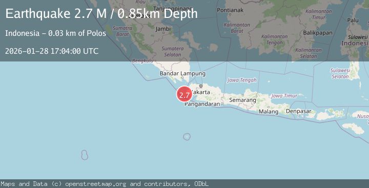
Earthquake Sunda Strait, Indonesia
Wed, 28 Jan 2026 17:03:57 GMT
Time1 hour ago
Location
-6.8703, 105.3173
Depth
26.1 KM
Event Summary
A 2.7 magnitude earthquake struck on Sunda Strait, Indonesia, at Wed, 28 Jan 2026 17:03:57 GMT. Depth: 26.076902km. Reviewed by BMKG seismologists, this minor quake occurred at a magnitude type of M.
Magnitude
2.7
M
Source
BMKG
Intensity
-
Agency Reports
1 Sources| Source | Magnitude | Depth | Time |
|---|---|---|---|
| BMKGPrimary | 2.7 | 26 km | 1 hour ago |
Earthquake Details
AutomaticEvent IDbmg2026byqj
Tsunami PotentialNo
Magnitude TypeM
Nearest Places
- Tanjung Karangpabayang6.0 km
- Tanjung Cangkuang6.6 km
- Ci Keusik7.0 km
- Ci Tandahan7.8 km
- Gunung Payung8.2 km
Comments
Join the discussion about this event.
Latest Earthquakes
4.1Mag
Celebes Sea
Time1 hour ago
Depth518.07 km
SourceBMKG (Automatic)
2.1Mag
Minahassa Peninsula, Sulawesi
Time1 hour ago
Depth5.00 km
SourceBMKG (Automatic)
3.8Mag
OFFSHORE EL SALVADOR
Time2 hours ago
Depth31.00 km
SourceINET (Automatic)
2.7Mag
Bali Region, Indonesia
Time2 hours ago
Depth46.02 km
SourceBMKG (Automatic)
2.3Mag
Halmahera, Indonesia
Time2 hours ago
Depth10.09 km
SourceBMKG (Automatic)
Nearby Earthquakes
2.9Mag
Sunda Strait, Indonesia
Time9 hours ago
Depth3.94 km
SourceBMKG (Automatic)
2.5Mag
SUNDA STRAIT, INDONESIA
Time3 days ago
Depth13.00 km
SourceBMKG (Automatic)
2.2Mag
Java, Indonesia
Time3 days ago
Depth17.14 km
SourceBMKG (Automatic)
4.8Mag
Java, Indonesia
Time2 days ago
Depth10.00 km
SourceBMKG (Automatic)
2.9Mag
Java, Indonesia
Time3 days ago
Depth6.94 km
SourceBMKG (Automatic)