Earthquake Tanimbar Islands Region, Indonesia
Wed, 28 Jan 2026 17:22:25 GMT
Time3 hours ago
Location
-7.4035, 130.2395
Depth
12.9 KM
Event Summary
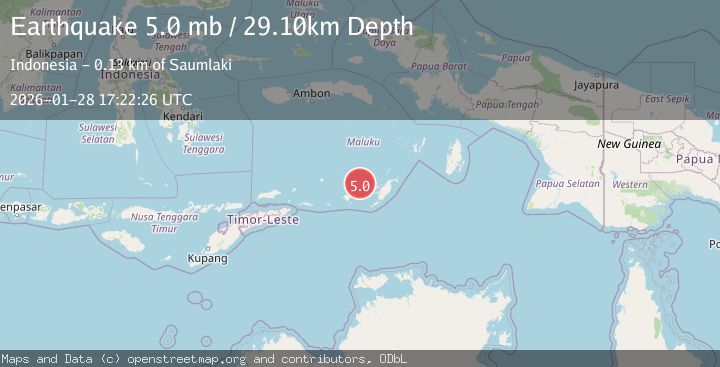
A 4.7 magnitude earthquake struck on Tanimbar Islands Region, Indonesia, at Wed, 28 Jan 2026 17:22:25 GMT. Depth: 12.850921km. Reviewed by BMKG seismologists, this light quake occurred at a magnitude type of M.
Magnitude
4.7
M
Source
BMKG
Intensity
-
Agency Reports
1 Sources| Source | Magnitude | Depth | Time |
|---|---|---|---|
| BMKGPrimary | 4.7 | 13 km | 3 hours ago |
Earthquake Details
AutomaticEvent IDbmg2026byqz
Tsunami PotentialNo
Magnitude TypeM
Nearest Places
- Ilhar42.1 km
- Welora42.2 km
- Desa Welora43.2 km
- Pulau Dawera43.7 km
- Desa Wiratan43.8 km
Comments
Join the discussion about this event.
Latest Earthquakes
2.1Mag
NORTHERN CALIFORNIA
Time3 hours ago
Depth-1.60 km
SourceNC (Automatic)
1.3Mag
15 km ESE of Lake Pillsbury, CA
Time3 hours ago
Depth9.06 km
SourceUSGS (Automatic)
2.2Mag
Sumba Region, Indonesia
Time3 hours ago
Depth63.49 km
SourceBMKG (Automatic)
2.7Mag
Minahassa Peninsula, Sulawesi
Time3 hours ago
Depth10.00 km
SourceBMKG (Automatic)
0.8Mag
2 km ESE of Fairbanks, Alaska
Time3 hours ago
Depth18.10 km
SourceUSGS (Automatic)
Nearby Earthquakes
3.6Mag
Tanimbar Islands Region, Indonesia
Time1 day ago
Depth224.21 km
SourceBMKG (Automatic)
5.9Mag
Banda Sea
Time1 week ago
Depth102.35 km
SourceBMKG (Automatic)
4.4Mag
Banda Sea
Time3 days ago
Depth141.54 km
SourceBMKG (Automatic)
4.5Mag
Banda Sea
Time6 days ago
Depth137.79 km
SourceUSGS
3.9Mag
Banda Sea
Time1 day ago
Depth247.75 km
SourceBMKG (Automatic)