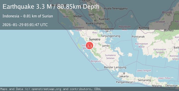
Earthquake Southern Sumatra, Indonesia
Thu, 29 Jan 2026 03:01:47 GMT
Time1 hour ago
Location
-1.2076, 100.7769
Depth
78.7 KM
Event Summary
A 3.1 magnitude earthquake struck on Southern Sumatra, Indonesia, at Thu, 29 Jan 2026 03:01:47 GMT. Depth: 78.72245km. Reviewed by BMKG seismologists, this minor quake occurred at a magnitude type of M.
Magnitude
3.1
M
Source
BMKG
Intensity
-
Agency Reports
1 Sources| Source | Magnitude | Depth | Time |
|---|---|---|---|
| BMKGPrimary | 3.1 | 79 km | 1 hour ago |
Earthquake Details
AutomaticEvent IDbmg2026bzkc
Tsunami PotentialNo
Magnitude TypeM
Nearest Places
- Gunung Paninjauan4.5 km
- Kabunairabu4.6 km
- Gunung Rasam4.8 km
- Kotabaru5.6 km
- Gunung Boleng5.7 km
Comments
Join the discussion about this event.
Latest Earthquakes
2.5Mag
WESTERN TEXAS
Time1 hour ago
Depth3.80 km
SourceTX (Automatic)
3.7Mag
GUATEMALA
Time1 hour ago
Depth93.00 km
SourceINET (Automatic)
3.4Mag
SAN JUAN, ARGENTINA
Time1 hour ago
Depth10.00 km
SourceNSNA (Automatic)
4.4Mag
NEAR EAST COAST OF HONSHU, JAPAN
Time1 hour ago
Depth30.00 km
SourceJMA (Automatic)
2.6Mag
WESTERN AUSTRALIA
Time1 hour ago
Depth10.00 km
SourceAUST (Automatic)
Nearby Earthquakes
2.6Mag
Southern Sumatra, Indonesia
Time1 week ago
Depth10.00 km
SourceBMKG (Automatic)
4.2Mag
Southern Sumatra, Indonesia
Time1 week ago
Depth56.32 km
SourceBMKG (Automatic)
3.8Mag
Southern Sumatra, Indonesia
Time1 week ago
Depth3.60 km
SourceBMKG (Automatic)
3.5Mag
Southern Sumatra, Indonesia
Time2 days ago
Depth46.40 km
SourceBMKG (Automatic)
2.5Mag
Southern Sumatra, Indonesia
Time2 days ago
Depth15.39 km
SourceBMKG (Automatic)