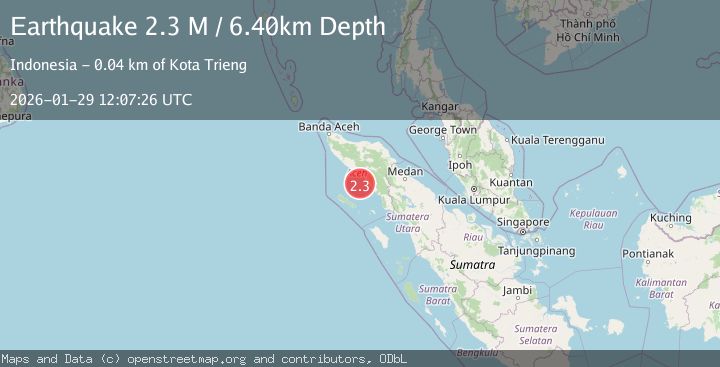
Earthquake Northern Sumatra, Indonesia
Thu, 29 Jan 2026 12:07:26 GMT
Time3 hours ago
Location
3.3864, 96.6918
Depth
6.4 KM
Event Summary
A 2.3 magnitude earthquake struck on Northern Sumatra, Indonesia, at Thu, 29 Jan 2026 12:07:26 GMT. Depth: 6.396937km. Reviewed by BMKG seismologists, this minor quake occurred at a magnitude type of M.
Magnitude
2.3
M
Source
BMKG
Intensity
-
Agency Reports
1 Sources| Source | Magnitude | Depth | Time |
|---|---|---|---|
| BMKGPrimary | 2.3 | 6 km | 3 hours ago |
Earthquake Details
AutomaticEvent IDbmg2026cacc
Tsunami PotentialNo
Magnitude TypeM
Nearest Places
- Ujung Manggeng33.6 km
- Kuala Udeung33.9 km
- Aluerambat34.1 km
- Krueng Suakkedai34.2 km
- Gampong Alue Rambot34.3 km
Comments
Join the discussion about this event.
Latest Earthquakes
3.0Mag
SAN JUAN, ARGENTINA
Time3 hours ago
Depth103.00 km
SourceNSNA (Automatic)
1.7Mag
CENTRAL TURKEY
Time3 hours ago
Depth7.00 km
SourceEMSC (Automatic)
1.1Mag
8 km NW of The Geysers, CA
Time3 hours ago
Depth1.57 km
SourceUSGS (Automatic)
3.0Mag
OFFSHORE EL SALVADOR
Time3 hours ago
Depth28.00 km
SourceINET (Automatic)
2.5Mag
Bali Sea
Time4 hours ago
Depth10.00 km
SourceBMKG (Automatic)
Nearby Earthquakes
2.5Mag
Northern Sumatra, Indonesia
Time4 days ago
Depth10.00 km
SourceBMKG (Automatic)
2.6Mag
NORTHERN SUMATRA, INDONESIA
Time1 day ago
Depth121.00 km
SourceBMKG (Automatic)
2.9Mag
Northern Sumatra, Indonesia
Time4 days ago
Depth30.75 km
SourceBMKG (Automatic)
2.3Mag
Northern Sumatra, Indonesia
Time6 days ago
Depth49.78 km
SourceBMKG (Automatic)
2.2Mag
Northern Sumatra, Indonesia
Time5 days ago
Depth2.00 km
SourceBMKG (Automatic)