Earthquake Minahassa Peninsula, Sulawesi
Thu, 29 Jan 2026 13:54:41 GMT
Time1 hour ago
Location
0.7392, 121.1406
Depth
64.6 KM
Event Summary
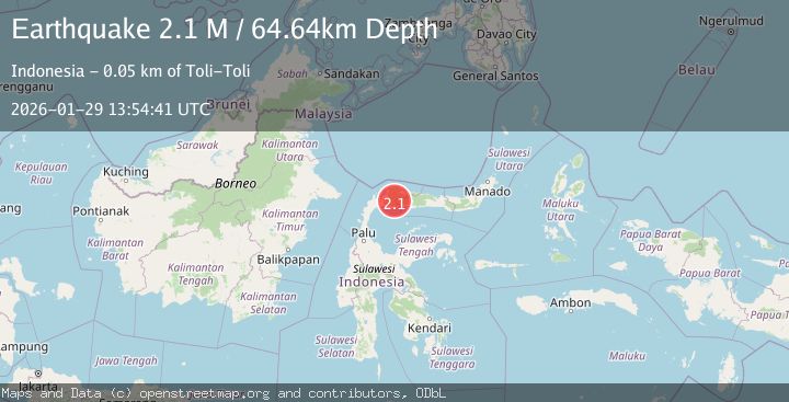
A 2.1 magnitude earthquake struck on Minahassa Peninsula, Sulawesi, at Thu, 29 Jan 2026 13:54:41 GMT. Depth: 64.643639km. Reviewed by BMKG seismologists, this minor quake occurred at a magnitude type of M.
Magnitude
2.1
M
Source
BMKG
Intensity
-
Agency Reports
1 Sources| Source | Magnitude | Depth | Time |
|---|---|---|---|
| BMKGPrimary | 2.1 | 65 km | 1 hour ago |
Earthquake Details
AutomaticEvent IDbmg2026cafq
Tsunami PotentialNo
Magnitude TypeM
Nearest Places
- Butakio Bukal3.0 km
- Mbukid Nosumulu Dedek4.4 km
- Buluye Salat5.5 km
- Butakio Labanti6.1 km
- Mbukid Totoluna6.2 km
Comments
Join the discussion about this event.
Latest Earthquakes
2.1Mag
Sulawesi, Indonesia
Time2 hours ago
Depth5.00 km
SourceBMKG (Automatic)
4.3Mag
South of Java, Indonesia
Time2 hours ago
Depth10.00 km
SourceBMKG (Automatic)
3.8Mag
NEAR EAST COAST OF HONSHU, JAPAN
Time2 hours ago
Depth30.00 km
SourceJMA (Automatic)
2.1Mag
Sumbawa Region, Indonesia
Time2 hours ago
Depth13.99 km
SourceBMKG (Automatic)
2.1Mag
CENTRAL CALIFORNIA
Time2 hours ago
Depth5.40 km
SourceNC (Automatic)
Nearby Earthquakes
2.7Mag
MINAHASA, SULAWESI, INDONESIA
Time3 days ago
Depth31.00 km
SourceBMKG (Automatic)
2.9Mag
Minahassa Peninsula, Sulawesi
Time7 hours ago
Depth59.25 km
SourceBMKG (Automatic)
3.6Mag
Minahassa Peninsula, Sulawesi
Time3 hours ago
Depth40.25 km
SourceBMKG (Automatic)
2.6Mag
Minahassa Peninsula, Sulawesi
Time6 days ago
Depth52.69 km
SourceBMKG (Automatic)
2.2Mag
Minahassa Peninsula, Sulawesi
Time1 week ago
Depth76.64 km
SourceBMKG (Automatic)