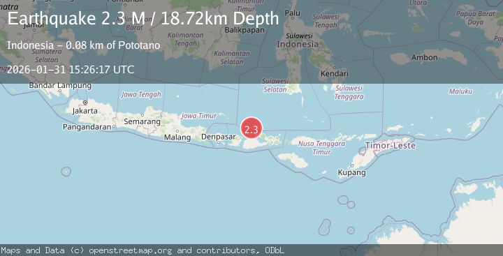
Earthquake Bali Sea
Sat, 31 Jan 2026 15:26:19 GMT
Time1 hour ago
Location
-7.8592, 117.3754
Depth
20.0 KM
Event Summary
A 2.1 magnitude earthquake struck on Bali Sea, at Sat, 31 Jan 2026 15:26:19 GMT. Depth: 19.990925km. Reviewed by BMKG seismologists, this minor quake occurred at a magnitude type of M.
Magnitude
2.1
M
Source
BMKG
Intensity
-
Agency Reports
1 Sources| Source | Magnitude | Depth | Time |
|---|---|---|---|
| BMKGPrimary | 2.1 | 20 km | 1 hour ago |
Earthquake Details
AutomaticEvent IDbmg2026cdzq
Tsunami PotentialNo
Magnitude TypeM
Nearest Places
- Gosong Sakunci20.3 km
- Pulau Sadapur21.2 km
- Gosong Sadapur29.5 km
- Desa Bajo Medang30.9 km
- Desa Bugis Medang31.2 km
Comments
Join the discussion about this event.
Latest Earthquakes
1.8Mag
21 km S of Denali National Park, Alaska
Time1 hour ago
Depth5.00 km
SourceUSGS (Automatic)
1.9Mag
2 km W of Elmendorf Air Force Base, Alaska
Time1 hour ago
Depth32.40 km
SourceUSGS (Automatic)
3.0Mag
TARAPACA, CHILE
Time1 hour ago
Depth51.30 km
SourceCSN (Automatic)
2.5Mag
Minahassa Peninsula, Sulawesi
Time1 hour ago
Depth42.16 km
SourceBMKG (Automatic)
3.0Mag
Northern Sumatra, Indonesia
Time1 hour ago
Depth5.00 km
SourceBMKG (Automatic)
Nearby Earthquakes
2.3Mag
Bali Sea
Time1 week ago
Depth10.00 km
SourceBMKG (Automatic)
2.5Mag
Bali Sea
Time2 days ago
Depth22.43 km
SourceBMKG (Automatic)
2.3Mag
Bali Sea
Time1 week ago
Depth10.00 km
SourceBMKG (Automatic)
2.3Mag
Bali Sea
Time1 day ago
Depth10.00 km
SourceBMKG (Automatic)
2.2Mag
Bali Sea
Time4 days ago
Depth23.43 km
SourceBMKG (Automatic)