Earthquake Bali Sea
Thu, 29 Jan 2026 07:04:16 GMT
Time2 hours ago
Location
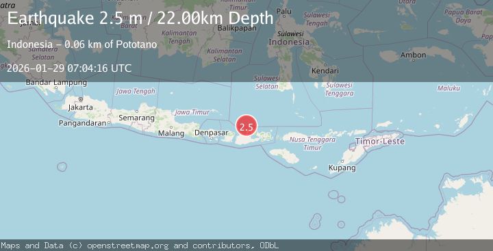
-7.8638, 117.4741
Depth
22.4 KM
Event Summary
A 2.5 magnitude earthquake struck on Bali Sea, at Thu, 29 Jan 2026 07:04:16 GMT. Depth: 22.432774km. Reviewed by BMKG seismologists, this minor quake occurred at a magnitude type of M.
Magnitude
2.5
M
Source
BMKG
Intensity
-
Agency Reports
1 Sources| Source | Magnitude | Depth | Time |
|---|---|---|---|
| BMKGPrimary | 2.5 | 22 km | 2 hours ago |
Earthquake Details
AutomaticEvent IDbmg2026bzsc
Tsunami PotentialNo
Magnitude TypeM
Nearest Places
- Tanjung Timor30.2 km
- Desa Bajo Medang31.1 km
- Gosong Sakunci31.1 km
- Pulau Sailus Kecil31.3 km
- Desa Poleonro31.4 km
Comments
Join the discussion about this event.
Latest Earthquakes
2.3Mag
WESTERN TURKEY
Time2 hours ago
Depth7.90 km
SourceKOERI (Automatic)
1.9Mag
2 km N of Yauco, Puerto Rico
Time2 hours ago
Depth18.42 km
SourceUSGS
1.8Mag
0 km NE of Redlands, CA
Time2 hours ago
Depth10.90 km
SourceUSGS (Automatic)
3.5Mag
MORO GULF, MINDANAO, PHILIPPINES
Time2 hours ago
Depth6.00 km
SourcePIVS (Automatic)
1.9Mag
4 km SSW of Yountville, CA
Time2 hours ago
Depth3.75 km
SourceUSGS (Automatic)
Nearby Earthquakes
2.3Mag
Bali Sea
Time5 days ago
Depth10.00 km
SourceBMKG (Automatic)
2.3Mag
Bali Sea
Time4 days ago
Depth10.00 km
SourceBMKG (Automatic)
2.2Mag
Bali Sea
Time2 days ago
Depth23.43 km
SourceBMKG (Automatic)
2.4Mag
Bali Sea
Time3 days ago
Depth10.00 km
SourceBMKG (Automatic)
2.3Mag
Bali Sea
Time3 hours ago
Depth10.00 km
SourceBMKG (Automatic)