Earthquake Sumba Region, Indonesia
Sun, 01 Feb 2026 16:52:58 GMT
Time2 days ago
Location
-9.1334, 119.5675
Depth
10.0 KM
Event Summary
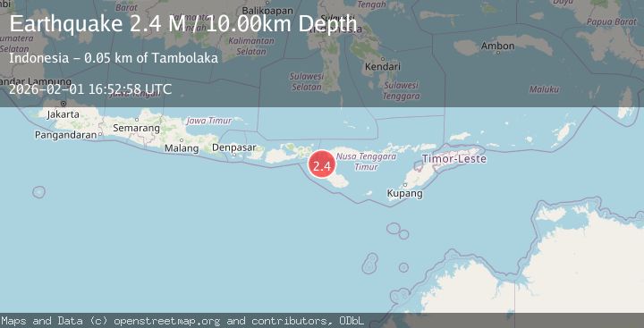
A 2.4 magnitude earthquake struck on Sumba Region, Indonesia, at Sun, 01 Feb 2026 16:52:58 GMT. Depth: 10km. Reviewed by BMKG seismologists, this minor quake occurred at a magnitude type of M.
Magnitude
2.4
M
Source
BMKG
Intensity
-
Agency Reports
1 Sources| Source | Magnitude | Depth | Time |
|---|---|---|---|
| BMKGPrimary | 2.4 | 10 km | 2 days ago |
Earthquake Details
AutomaticEvent IDbmg2026cfya
Tsunami PotentialNo
Magnitude TypeM
Nearest Places
- Tanjung Laramanipa24.1 km
- Tanjung Wanda24.6 km
- Tanjung Hendak24.7 km
- Memboro Road26.0 km
- Memboro26.2 km
Comments
Join the discussion about this event.
Latest Earthquakes
0.3Mag
6 km NW of The Geysers, CA
Time2 hours ago
Depth3.41 km
SourceUSGS (Automatic)
1.3Mag
WESTERN TURKEY
Time2 hours ago
Depth7.00 km
SourceAFAD (Automatic)
1.7Mag
58 km S of Whites City, New Mexico
Time2 hours ago
Depth4.46 km
SourceUSGS (Automatic)
2.0Mag
Southern Sumatra, Indonesia
Time2 hours ago
Depth4.94 km
SourceBMKG (Automatic)
2.1Mag
NEAR SOUTH COAST OF FRANCE
Time2 hours ago
Depth5.00 km
SourceReNaSS (Automatic)
Nearby Earthquakes
2.9Mag
Sumba Region, Indonesia
Time1 week ago
Depth4.58 km
SourceBMKG (Automatic)
2.7Mag
Sumba Region, Indonesia
Time3 hours ago
Depth23.21 km
SourceBMKG (Automatic)
2.1Mag
Flores Region, Indonesia
Time1 week ago
Depth10.00 km
SourceBMKG (Automatic)
2.2Mag
Sumba Region, Indonesia
Time1 week ago
Depth5.00 km
SourceBMKG (Automatic)
2.5Mag
Sumba Region, Indonesia
Time1 week ago
Depth65.25 km
SourceBMKG (Automatic)