Earthquake Southern Molucca Sea
Sun, 01 Feb 2026 19:43:02 GMT
Time1 day ago
Location
-0.9947, 126.2791
Depth
4.8 KM
Event Summary
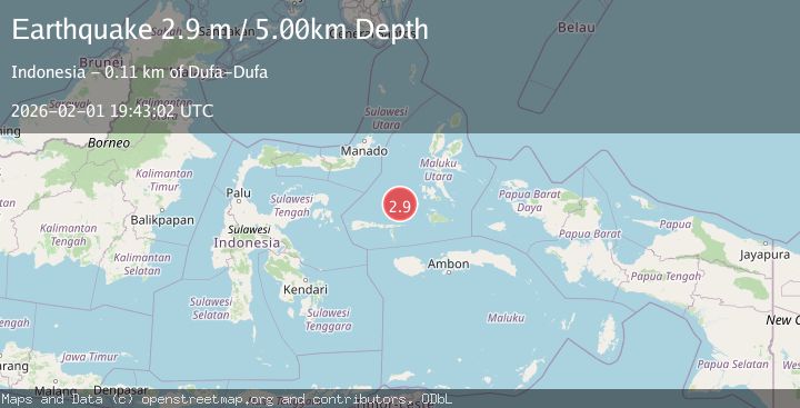
A 2.9 magnitude earthquake struck on Southern Molucca Sea, at Sun, 01 Feb 2026 19:43:02 GMT. Depth: 4.750127km. Reviewed by BMKG seismologists, this minor quake occurred at a magnitude type of M.
Magnitude
2.9
M
Source
BMKG
Intensity
-
Agency Reports
1 Sources| Source | Magnitude | Depth | Time |
|---|---|---|---|
| BMKGPrimary | 2.9 | 5 km | 1 day ago |
Earthquake Details
AutomaticEvent IDbmg2026cgdr
Tsunami PotentialNo
Magnitude TypeM
Nearest Places
- Batjan Basin52.4 km
- Mangole Basin56.5 km
- Pulau Tabobi90.8 km
- Pulau Fatsati91.2 km
- Tanjung Sewikonati91.5 km
Comments
Join the discussion about this event.
Latest Earthquakes
2.3Mag
Sulawesi, Indonesia
Time3 minutes ago
Depth6.12 km
SourceBMKG (Automatic)
1.8Mag
68 km ESE of Cantwell, Alaska
Time6 minutes ago
Depth2.20 km
SourceUSGS (Automatic)
1.5Mag
13 km E of Pearsall, Texas
Time27 minutes ago
Depth8.04 km
SourceUSGS (Automatic)
3.0Mag
Southern Sumatra, Indonesia
Time29 minutes ago
Depth10.00 km
SourceBMKG (Automatic)
1.2Mag
24 km NE of Minto, Alaska
Time30 minutes ago
Depth6.60 km
SourceUSGS (Automatic)
Nearby Earthquakes
2.4Mag
Halmahera, Indonesia
Time4 days ago
Depth18.32 km
SourceBMKG (Automatic)
3.4Mag
Northern Molucca Sea
Time2 days ago
Depth1.11 km
SourceBMKG (Automatic)
4.4Mag
Southern Molucca Sea
Time5 days ago
Depth10.00 km
SourceBMKG (Automatic)
2.9Mag
Halmahera, Indonesia
Time1 week ago
Depth115.57 km
SourceBMKG (Automatic)
3.9Mag
Ceram Sea
Time1 week ago
Depth10.00 km
SourceBMKG (Automatic)