Earthquake Halmahera, Indonesia
Mon, 02 Feb 2026 10:28:14 GMT
Time16 hours ago
Location
2.8006, 128.5397
Depth
217.7 KM
Event Summary
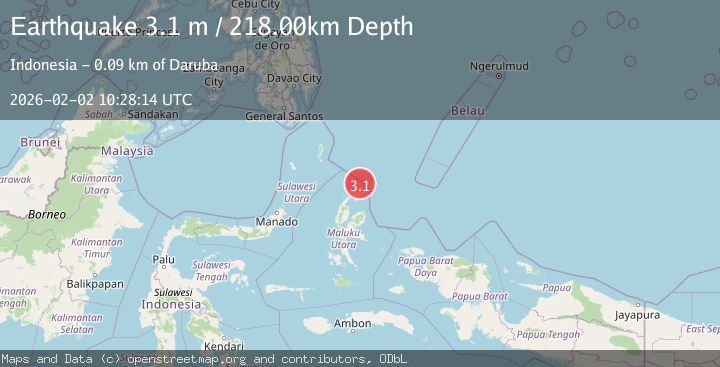
A 3.1 magnitude earthquake struck on Halmahera, Indonesia, at Mon, 02 Feb 2026 10:28:14 GMT. Depth: 217.675003km. Reviewed by BMKG seismologists, this minor quake occurred at a magnitude type of M.
Magnitude
3.1
M
Source
BMKG
Intensity
-
Agency Reports
1 Sources| Source | Magnitude | Depth | Time |
|---|---|---|---|
| BMKGPrimary | 3.1 | 218 km | 16 hours ago |
Earthquake Details
AutomaticEvent IDbmg2026chgv
Tsunami PotentialNo
Magnitude TypeM
Nearest Places
- Tanjung Sopi17.7 km
- Kakaibabao18.9 km
- Tanjung Modiu20.6 km
- Papuamalolu21.4 km
- Teluk Sopi22.9 km
Comments
Join the discussion about this event.
Latest Earthquakes
1.1Mag
8 km NNW of Pinnacles, CA
Time16 hours ago
Depth5.61 km
SourceUSGS (Automatic)
2.3Mag
Northern Sumatra, Indonesia
Time16 hours ago
Depth3.46 km
SourceBMKG (Automatic)
1.2Mag
SWITZERLAND
Time16 hours ago
Depth-1.00 km
SourceETHZ (Automatic)
3.3Mag
TAIWAN REGION
Time16 hours ago
Depth30.00 km
SourcePIVS (Automatic)
2.6Mag
TARAPACA, CHILE
Time16 hours ago
Depth87.10 km
SourceCSN (Automatic)
Nearby Earthquakes
3.4Mag
Halmahera, Indonesia
Time2 weeks ago
Depth197.00 km
SourceBMKG (Automatic)
3.1Mag
HALMAHERA, INDONESIA
Time1 week ago
Depth186.00 km
SourceBMKG (Automatic)
3.1Mag
Halmahera, Indonesia
Time2 days ago
Depth118.67 km
SourceBMKG (Automatic)
3.5Mag
Halmahera, Indonesia
Time1 week ago
Depth209.55 km
SourceBMKG (Automatic)
4.1Mag
North of Halmahera, Indonesia
Time3 days ago
Depth5.50 km
SourceBMKG (Automatic)