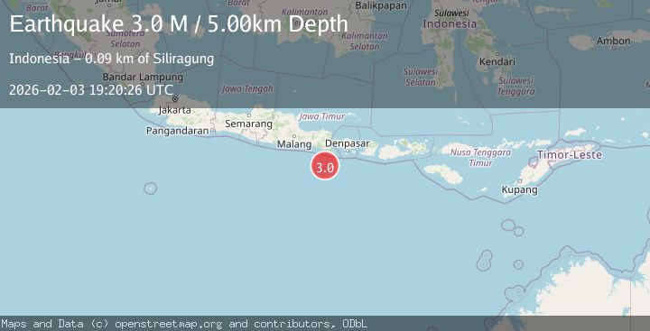
Earthquake South of Bali, Indonesia
Tue, 03 Feb 2026 19:20:26 GMT
Time21 hours ago
Location
-9.4253, 114.2991
Depth
10.0 KM
Event Summary
A 2.7 magnitude earthquake struck on South of Bali, Indonesia, at Tue, 03 Feb 2026 19:20:26 GMT. Depth: 10km. Reviewed by BMKG seismologists, this minor quake occurred at a magnitude type of M.
Magnitude
2.7
M
Source
BMKG
Intensity
-
Agency Reports
1 Sources| Source | Magnitude | Depth | Time |
|---|---|---|---|
| BMKGPrimary | 2.7 | 10 km | 21 hours ago |
Earthquake Details
AutomaticEvent IDbmg2026cjtw
Tsunami PotentialNo
Magnitude TypeM
Nearest Places
- Pulau Batu Mandi73.6 km
- Kali Bindo73.8 km
- Tanjung Bantenan76.3 km
- Tanjung Purwo76.6 km
- Crowne Plaza Shenzhen Longgang City Centre77.8 km
Comments
Join the discussion about this event.
Latest Earthquakes
1.5Mag
52 km SSE of Whites City, New Mexico
Time21 hours ago
Depth4.26 km
SourceUSGS (Automatic)
2.5Mag
South of Java, Indonesia
Time21 hours ago
Depth10.00 km
SourceBMKG (Automatic)
2.0Mag
CYPRUS REGION
Time21 hours ago
Depth28.40 km
SourceKOERI (Automatic)
2.3Mag
West Papua Region, Indonesia
Time21 hours ago
Depth10.00 km
SourceBMKG (Automatic)
3.0Mag
MINDANAO, PHILIPPINES
Time21 hours ago
Depth10.00 km
SourcePIVS (Automatic)
Nearby Earthquakes
2.7Mag
South of Bali, Indonesia
Time1 week ago
Depth21.49 km
SourceBMKG (Automatic)
2.8Mag
South of Bali, Indonesia
Time5 days ago
Depth89.10 km
SourceBMKG (Automatic)
2.7Mag
South of Bali, Indonesia
Time1 day ago
Depth10.00 km
SourceBMKG (Automatic)
3.0Mag
South of Bali, Indonesia
Time1 week ago
Depth21.74 km
SourceBMKG (Automatic)
2.9Mag
South of Java, Indonesia
Time1 week ago
Depth12.47 km
SourceBMKG (Automatic)