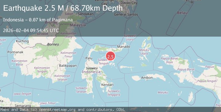
Earthquake Minahassa Peninsula, Sulawesi
Wed, 04 Feb 2026 09:54:43 GMT
Time4 hours ago
Location
-0.3374, 122.7794
Depth
2.5 KM
Event Summary
A 2.4 magnitude earthquake struck on Minahassa Peninsula, Sulawesi, at Wed, 04 Feb 2026 09:54:43 GMT. Depth: 2.458782km. Reviewed by BMKG seismologists, this minor quake occurred at a magnitude type of M.
Magnitude
2.4
M
Source
BMKG
Intensity
-
Agency Reports
1 Sources| Source | Magnitude | Depth | Time |
|---|---|---|---|
| BMKGPrimary | 2.4 | 2 km | 4 hours ago |
Earthquake Details
AutomaticEvent IDbmg2026ckws
Tsunami PotentialNo
Magnitude TypeM
Nearest Places
- Pulau Dondolang18.8 km
- Pulau Ban21.3 km
- Pulau Sendiri22.4 km
- Pulau Bobatise23.1 km
- Pulau Bobatdaka23.7 km
Comments
Join the discussion about this event.
Latest Earthquakes
3.8Mag
OFF E. COAST OF N. ISLAND, N.Z.
Time4 hours ago
Depth211.80 km
SourceGNS (Automatic)
2.0Mag
WESTERN TURKEY
Time5 hours ago
Depth9.10 km
SourceKOERI (Automatic)
1.4Mag
5 km N of Little Lake, CA
Time5 hours ago
Depth2.51 km
SourceUSGS (Automatic)
2.8Mag
9 km WNW of Delta, B.C., MX
Time5 hours ago
Depth6.20 km
SourceUSGS (Automatic)
2.0Mag
NEAR SOUTH COAST OF FRANCE
Time5 hours ago
Depth5.00 km
SourceReNaSS (Automatic)
Nearby Earthquakes
2.6Mag
Minahassa Peninsula, Sulawesi
Time6 days ago
Depth10.00 km
SourceBMKG (Automatic)
2.6Mag
Minahassa Peninsula, Sulawesi
Time1 week ago
Depth59.44 km
SourceBMKG (Automatic)
5.1Mag
84 km N of Luwuk, Indonesia
Time1 week ago
Depth92.62 km
SourceUSGS
2.4Mag
Minahassa Peninsula, Sulawesi
Time1 week ago
Depth79.94 km
SourceBMKG (Automatic)
3.9Mag
Minahassa Peninsula, Sulawesi
Time1 week ago
Depth29.89 km
SourceBMKG (Automatic)