Earthquake Bali Sea
Wed, 04 Feb 2026 15:58:37 GMT
Time2 hours ago
Location
-7.1006, 114.2113
Depth
13.9 KM
Event Summary
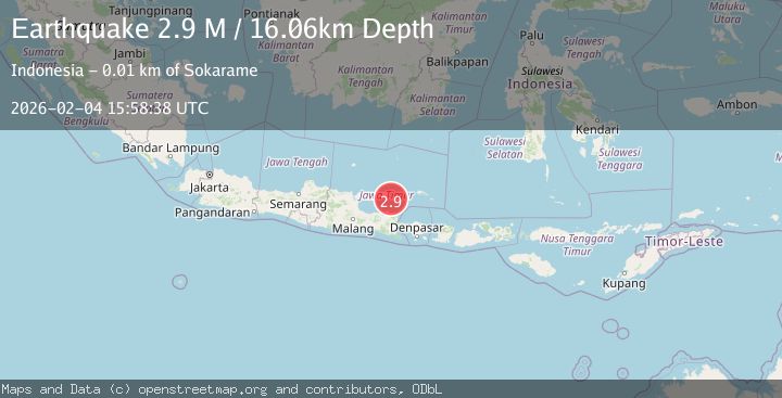
A 2.8 magnitude earthquake struck on Bali Sea, at Wed, 04 Feb 2026 15:58:37 GMT. Depth: 13.94566km. Reviewed by BMKG seismologists, this minor quake occurred at a magnitude type of M.
Magnitude
2.8
M
Source
BMKG
Intensity
-
Agency Reports
1 Sources| Source | Magnitude | Depth | Time |
|---|---|---|---|
| BMKGPrimary | 2.8 | 14 km | 2 hours ago |
Earthquake Details
AutomaticEvent IDbmg2026clit
Tsunami PotentialNo
Magnitude TypeM
Nearest Places
- Trebung Road6.4 km
- Tarebung6.8 km
- Pulau Sapudi Lighthouse6.8 km
- Selat Sapudi8.0 km
- Gilian Barat8.2 km
Comments
Join the discussion about this event.
Latest Earthquakes
2.7Mag
West Papua Region, Indonesia
Time2 hours ago
Depth10.00 km
SourceBMKG (Automatic)
2.3Mag
Flores Region, Indonesia
Time2 hours ago
Depth10.00 km
SourceBMKG (Automatic)
3.1Mag
Off West Coast of Northern Sumatra
Time2 hours ago
Depth82.66 km
SourceBMKG (Automatic)
2.6Mag
West Papua Region, Indonesia
Time2 hours ago
Depth9.76 km
SourceBMKG (Automatic)
1.5Mag
29 km SSE of Midland, Texas
Time2 hours ago
Depth3.20 km
SourceUSGS (Automatic)
Nearby Earthquakes
2.7Mag
Bali Sea
Time1 week ago
Depth22.23 km
SourceBMKG (Automatic)
2.5Mag
Bali Sea
Time1 week ago
Depth14.54 km
SourceBMKG (Automatic)
3.1Mag
Bali Region, Indonesia
Time1 day ago
Depth12.36 km
SourceBMKG (Automatic)
2.5Mag
Java, Indonesia
Time6 days ago
Depth20.42 km
SourceBMKG (Automatic)
2.5Mag
Java, Indonesia
Time1 week ago
Depth76.84 km
SourceBMKG (Automatic)