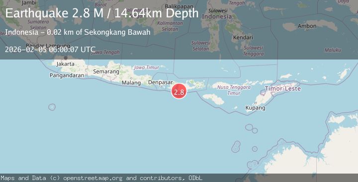
Earthquake Sumbawa Region, Indonesia
Thu, 05 Feb 2026 06:00:07 GMT
Time1 hour ago
Location
-9.1400, 116.8620
Depth
12.8 KM
Event Summary
A 2.7 magnitude earthquake struck on Sumbawa Region, Indonesia, at Thu, 05 Feb 2026 06:00:07 GMT. Depth: 12.772969km. Reviewed by BMKG seismologists, this minor quake occurred at a magnitude type of M.
Magnitude
2.7
M
Source
BMKG
Intensity
-
Agency Reports
1 Sources| Source | Magnitude | Depth | Time |
|---|---|---|---|
| BMKGPrimary | 2.7 | 13 km | 1 hour ago |
Earthquake Details
AutomaticEvent IDbmg2026cmkm
Tsunami PotentialNo
Magnitude TypeM
Nearest Places
- Tanjung Tatar8.5 km
- Teluk Tatar9.2 km
- Teluk Senutuk9.3 km
- Tatar10.2 km
- Brang Labuan11.3 km
Comments
Join the discussion about this event.
Latest Earthquakes
2.3Mag
SAN FRANCISCO BAY AREA, CALIF.
Time1 hour ago
Depth3.10 km
SourceNC (Automatic)
1.7Mag
13 km ESE of Pearsall, Texas
Time1 hour ago
Depth9.64 km
SourceUSGS (Automatic)
2.3Mag
NEVADA
Time1 hour ago
Depth0.00 km
SourceNN (Automatic)
1.0Mag
NORTHERN ITALY
Time1 hour ago
Depth18.00 km
SourceOGS (Automatic)
4.3Mag
OFFSHORE EL SALVADOR
Time1 hour ago
Depth58.20 km
SourceNEIC (Automatic)
Nearby Earthquakes
2.5Mag
Sumbawa Region, Indonesia
Time3 days ago
Depth6.87 km
SourceBMKG (Automatic)
2.2Mag
Sumbawa Region, Indonesia
Time1 week ago
Depth72.67 km
SourceBMKG (Automatic)
2.2Mag
Sumbawa Region, Indonesia
Time1 week ago
Depth11.32 km
SourceBMKG (Automatic)
2.2Mag
Sumbawa Region, Indonesia
Time6 days ago
Depth10.00 km
SourceBMKG (Automatic)
2.1Mag
Sumbawa Region, Indonesia
Time1 week ago
Depth10.00 km
SourceBMKG (Automatic)