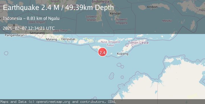
Earthquake Sumba Region, Indonesia
Sat, 07 Feb 2026 12:34:21 GMT
Time1 day ago
Location
-10.2950, 120.5246
Depth
49.4 KM
Event Summary
A 2.4 magnitude earthquake struck on Sumba Region, Indonesia, at Sat, 07 Feb 2026 12:34:21 GMT. Depth: 49.39257km. Reviewed by BMKG seismologists, this minor quake occurred at a magnitude type of M.
Magnitude
2.4
M
Source
BMKG
Intensity
-
Agency Reports
1 Sources| Source | Magnitude | Depth | Time |
|---|---|---|---|
| BMKGPrimary | 2.4 | 49 km | 1 day ago |
Earthquake Details
AutomaticEvent IDbmg2026cqom
Tsunami PotentialNo
Magnitude TypeM
Nearest Places
- Tanjung Watuparonu5.1 km
- Tanjung Warumanggit5.4 km
- Luku Worano5.7 km
- Worano5.9 km
- Luku Lahaburi6.3 km
Comments
Join the discussion about this event.
Latest Earthquakes
1.8Mag
26 km SE of Susitna North, Alaska
Time1 hour ago
Depth23.30 km
SourceUSGS (Automatic)
1.2Mag
23 km N of Borrego Springs, CA
Time2 hours ago
Depth3.28 km
SourceUSGS (Automatic)
2.1Mag
Sumba Region, Indonesia
Time2 hours ago
Depth1.35 km
SourceBMKG (Automatic)
1.9Mag
WESTERN TURKEY
Time2 hours ago
Depth9.60 km
SourceAFAD (Automatic)
2.3Mag
West Papua, Indonesia
Time2 hours ago
Depth10.00 km
SourceBMKG (Automatic)
Nearby Earthquakes
2.3Mag
Sumba Region, Indonesia
Time1 day ago
Depth24.06 km
SourceBMKG (Automatic)
2.8Mag
Sumba Region, Indonesia
Time2 weeks ago
Depth25.99 km
SourceBMKG (Automatic)
2.0Mag
Sumba Region, Indonesia
Time2 hours ago
Depth14.65 km
SourceBMKG (Automatic)
2.1Mag
Sumba Region, Indonesia
Time1 week ago
Depth24.50 km
SourceBMKG (Automatic)
2.7Mag
Sumba Region, Indonesia
Time2 weeks ago
Depth14.72 km
SourceBMKG (Automatic)