Earthquake West Papua, Indonesia
Sun, 08 Feb 2026 15:54:24 GMT
Time1 hour ago
Location
-3.1194, 139.5262
Depth
10.0 KM
Event Summary
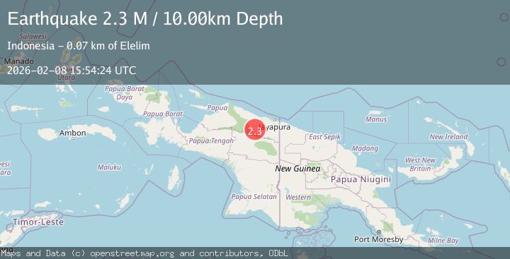
A 2.3 magnitude earthquake struck on West Papua, Indonesia, at Sun, 08 Feb 2026 15:54:24 GMT. Depth: 10km. Reviewed by BMKG seismologists, this minor quake occurred at a magnitude type of M.
Magnitude
2.3
M
Source
BMKG
Intensity
-
Agency Reports
1 Sources| Source | Magnitude | Depth | Time |
|---|---|---|---|
| BMKGPrimary | 2.3 | 10 km | 1 hour ago |
Earthquake Details
AutomaticEvent IDbmg2026csqp
Tsunami PotentialNo
Magnitude TypeM
Nearest Places
- Kampung Umbron15.0 km
- Kampung Tetom19.5 km
- Kampung Kiren20.6 km
- Barito25.8 km
- Kampung Krim Podena26.5 km
Comments
Join the discussion about this event.
Latest Earthquakes
2.5Mag
39 km WSW of Salamatof, Alaska
Time1 hour ago
Depth81.70 km
SourceUSGS (Automatic)
2.1Mag
STRAIT OF GIBRALTAR
Time1 hour ago
Depth0.00 km
SourceIGN (Automatic)
4.2Mag
Southern Molucca Sea
Time2 hours ago
Depth70.38 km
SourceBMKG (Automatic)
2.5Mag
JAVA, INDONESIA
Time2 hours ago
Depth19.00 km
SourceBMKG (Automatic)
1.9Mag
SPAIN
Time2 hours ago
Depth0.00 km
SourceIGN (Automatic)
Nearby Earthquakes
2.7Mag
West Papua, Indonesia
Time3 days ago
Depth52.18 km
SourceBMKG (Automatic)
3.8Mag
Near North Coast of West Papua
Time11 hours ago
Depth13.28 km
SourceBMKG (Automatic)
3.5Mag
Near North Coast of West Papua
Time1 week ago
Depth9.75 km
SourceBMKG (Automatic)
3.5Mag
Near North Coast of West Papua
Time2 weeks ago
Depth67.58 km
SourceBMKG (Automatic)
2.8Mag
Near North Coast of West Papua
Time3 days ago
Depth10.00 km
SourceBMKG (Automatic)