Earthquake Flores Region, Indonesia
Sat, 07 Feb 2026 22:50:01 GMT
Time1 hour ago
Location
-8.3444, 119.5668
Depth
144.7 KM
Event Summary
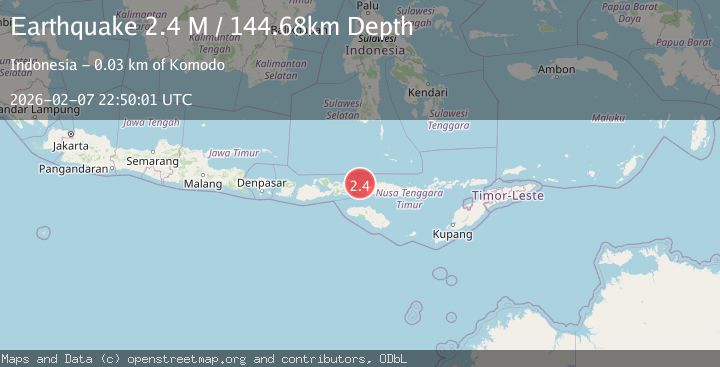
A 2.4 magnitude earthquake struck on Flores Region, Indonesia, at Sat, 07 Feb 2026 22:50:01 GMT. Depth: 144.683456km. Reviewed by BMKG seismologists, this minor quake occurred at a magnitude type of M.
Magnitude
2.4
M
Source
BMKG
Intensity
-
Agency Reports
1 Sources| Source | Magnitude | Depth | Time |
|---|---|---|---|
| BMKGPrimary | 2.4 | 145 km | 1 hour ago |
Earthquake Details
AutomaticEvent IDbmg2026criv
Tsunami PotentialNo
Magnitude TypeM
Nearest Places
- Gili Lawalaut11.8 km
- Gili Lawadarat14.0 km
- Teluk Gililawa14.9 km
- Toro Batumoncong15.3 km
- Loho Gebah15.6 km
Comments
Join the discussion about this event.
Latest Earthquakes
2.1Mag
Sulawesi, Indonesia
Time5 minutes ago
Depth6.10 km
SourceBMKG (Automatic)
1.8Mag
24 km SW of Independence, CA
Time8 minutes ago
Depth9.10 km
SourceUSGS (Automatic)
2.1Mag
WESTERN TEXAS
Time11 minutes ago
Depth2.80 km
SourceTX (Automatic)
1.0Mag
7 km E of Fox, Alaska
Time12 minutes ago
Depth4.00 km
SourceUSGS (Automatic)
0.8Mag
2 km NW of The Geysers, CA
Time12 minutes ago
Depth2.04 km
SourceUSGS (Automatic)
Nearby Earthquakes
2.4Mag
Flores Region, Indonesia
Time6 days ago
Depth156.34 km
SourceBMKG (Automatic)
2.5Mag
Flores Region, Indonesia
Time2 weeks ago
Depth147.07 km
SourceBMKG (Automatic)
2.5Mag
Flores Region, Indonesia
Time1 week ago
Depth179.70 km
SourceBMKG (Automatic)
2.7Mag
Flores Region, Indonesia
Time2 weeks ago
Depth160.88 km
SourceBMKG (Automatic)
3.3Mag
Flores Region, Indonesia
Time1 week ago
Depth188.75 km
SourceBMKG (Automatic)