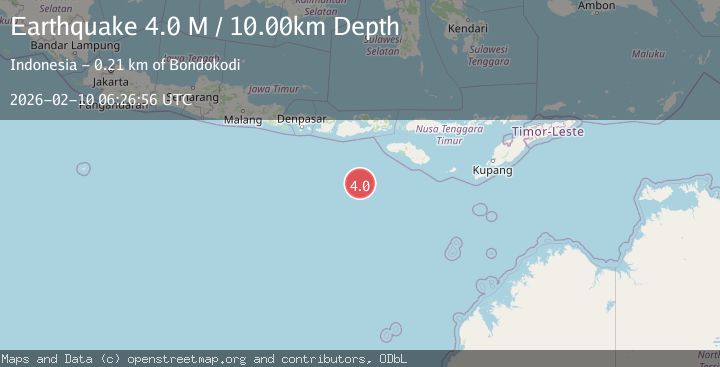
Earthquake Sumbawa Region, Indonesia
Tue, 10 Feb 2026 06:27:14 GMT
Time6 hours ago
Location
-9.6894, 117.6581
Depth
63.1 KM
Event Summary
A 3.0 magnitude earthquake struck on Sumbawa Region, Indonesia, at Tue, 10 Feb 2026 06:27:14 GMT. Depth: 63.119762km. Reviewed by BMKG seismologists, this minor quake occurred at a magnitude type of M.
Magnitude
3.0
M
Source
BMKG
Intensity
-
Agency Reports
1 Sources| Source | Magnitude | Depth | Time |
|---|---|---|---|
| BMKGPrimary | 3.0 | 63 km | 6 hours ago |
Earthquake Details
ManualEvent IDbmg2026cvoy
Tsunami PotentialNo
Magnitude TypeM
Nearest Places
- Tanjung Liongsong73.5 km
- Sungai Dodo77.0 km
- Tanjung Lesek77.0 km
- Teluk Sarang78.0 km
- Nanga Sumpee78.2 km
Comments
Join the discussion about this event.
Latest Earthquakes
0.7Mag
15 km ENE of Mammoth Lakes, CA
Time6 hours ago
Depth3.07 km
SourceUSGS (Automatic)
1.6Mag
60 km S of Whites City, New Mexico
Time6 hours ago
Depth4.37 km
SourceUSGS (Automatic)
2.4Mag
Sumbawa Region, Indonesia
Time6 hours ago
Depth24.18 km
SourceBMKG
2.6Mag
Near North Coast of West Papua
Time6 hours ago
Depth42.25 km
SourceBMKG
1.4Mag
13 km ESE of Olancha, CA
Time6 hours ago
Depth7.28 km
SourceUSGS (Automatic)
Nearby Earthquakes
2.2Mag
Sumbawa Region, Indonesia
Time22 hours ago
Depth28.51 km
SourceBMKG (Automatic)
2.0Mag
Sumbawa Region, Indonesia
Time1 week ago
Depth23.59 km
SourceBMKG (Automatic)
2.5Mag
Sumbawa Region, Indonesia
Time2 days ago
Depth24.83 km
SourceBMKG (Automatic)
2.8Mag
Sumbawa Region, Indonesia
Time2 weeks ago
Depth72.60 km
SourceBMKG (Automatic)
2.4Mag
Sumbawa Region, Indonesia
Time2 weeks ago
Depth24.27 km
SourceBMKG (Automatic)