Earthquake Sumbawa Region, Indonesia
Tue, 10 Feb 2026 10:10:51 GMT
Time1 week ago
Location
-8.0698, 117.6744
Depth
4.1 KM
Event Summary
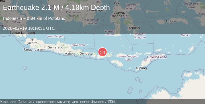
A 2.1 magnitude earthquake struck on Sumbawa Region, Indonesia, at Tue, 10 Feb 2026 10:10:51 GMT. Depth: 4.097525km. Reviewed by BMKG seismologists, this minor quake occurred at a magnitude type of M.
Magnitude
2.1
M
Source
BMKG
Intensity
-
Agency Reports
1 Sources| Source | Magnitude | Depth | Time |
|---|---|---|---|
| BMKGPrimary | 2.1 | 4 km | 1 week ago |
Earthquake Details
ManualEvent IDbmg2026cvwh
Tsunami PotentialNo
Magnitude TypeM
Nearest Places
- Satonda Peak8.9 km
- Tanjung Panda9.0 km
- Pulau Satonda9.1 km
- Teluk Patedong9.3 km
- Ndano Satonda9.4 km
Comments
Join the discussion about this event.
Latest Earthquakes
3.2Mag
Antofagasta, Chile
Time1 hour ago
Depth124.27 km
SourceVYT (Automatic)
1.7Mag
Kenai Peninsula, Alaska
Time1 hour ago
Depth28.44 km
SourceVYT (Automatic)
1.7Mag
Tarapaca, Chile
Time1 hour ago
Depth6.47 km
SourceVYT (Automatic)
1.9Mag
Central Alaska
Time1 hour ago
Depth81.18 km
SourceVYT (Automatic)
1.2Mag
21 km ENE of Little Lake, CA
Time1 hour ago
Depth0.90 km
SourceUSGS (Automatic)
Nearby Earthquakes
3.0Mag
SUMBAWA REGION, INDONESIA
Time3 years ago
Depth18.00 km
SourceDJA (Automatic)
3.1Mag
Sumbawa Region, Indonesia
Time2 weeks ago
Depth10.00 km
SourceBMKG (Automatic)
2.2Mag
Sumbawa Region, Indonesia
Time2 weeks ago
Depth16.86 km
SourceBMKG (Automatic)
2.1Mag
Sumbawa Region, Indonesia
Time2 weeks ago
Depth10.00 km
SourceBMKG (Automatic)
2.0Mag
Sumbawa Region, Indonesia
Time2 weeks ago
Depth24.75 km
SourceBMKG (Automatic)