Earthquake Talaud Islands, Indonesia
Fri, 13 Feb 2026 18:56:45 GMT
Time5 days ago
Location
3.2841, 127.9933
Depth
98.6 KM
Event Summary
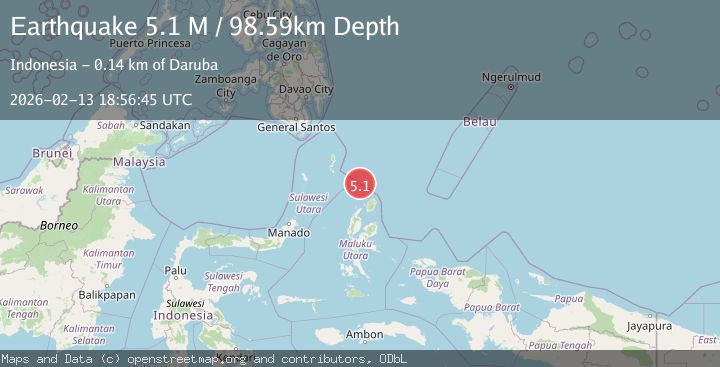
A 5.1 magnitude earthquake struck on Talaud Islands, Indonesia, at Fri, 13 Feb 2026 18:56:45 GMT. Depth: 98.5895km. Reviewed by BMKG seismologists, this moderate quake occurred at a magnitude type of M.
Magnitude
5.1
M
Source
BMKG
Intensity
-
Agency Reports
1 Sources| Source | Magnitude | Depth | Time |
|---|---|---|---|
| BMKGPrimary | 5.1 | 99 km | 5 days ago |
Earthquake Details
ManualEvent IDbmg2026dcae
Tsunami PotentialNo
Magnitude TypeM
Nearest Places
- Morotai Basin31.6 km
- Pulau Karis54.8 km
- Snellius Ridge79.6 km
- Tanjung Padangi92.8 km
- Tanjung Berri Berri93.0 km
Comments
Join the discussion about this event.
Latest Earthquakes
2.3Mag
Antofagasta, Chile
Time5 hours ago
Depth0.00 km
SourceVYT (Automatic)
1.2Mag
Southern Alaska
Time5 hours ago
Depth75.93 km
SourceVYT (Automatic)
2.2Mag
Southeastern Alaska
Time5 hours ago
Depth0.00 km
SourceVYT (Automatic)
1.6Mag
13 km SE of Balmorhea, Texas
Time6 hours ago
Depth3.50 km
SourceUSGS (Automatic)
2.0Mag
Kenai Peninsula, Alaska
Time6 hours ago
Depth51.51 km
SourceVYT (Automatic)
Nearby Earthquakes
4.0Mag
NORTH OF HALMAHERA, INDONESIA
Time6 years ago
Depth147.00 km
SourceDJA (Automatic)
4.0Mag
NORTH OF HALMAHERA, INDONESIA
Time5 years ago
Depth152.00 km
SourceDJA (Automatic)
4.0Mag
NORTH OF HALMAHERA, INDONESIA
Time2 years ago
Depth29.00 km
SourceBMKG (Automatic)
4.0Mag
NORTH OF HALMAHERA, INDONESIA
Time7 years ago
Depth22.00 km
SourceDJA (Automatic)
3.5Mag
Talaud Islands, Indonesia
Time2 weeks ago
Depth10.00 km
SourceBMKG (Automatic)