Earthquake Philippine Islands Region
Sat, 14 Feb 2026 17:22:58 GMT
Time4 days ago
Location
5.6639, 127.2168
Depth
10.0 KM
Event Summary
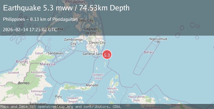
A 5.3 magnitude earthquake struck on Philippine Islands Region, at Sat, 14 Feb 2026 17:22:58 GMT. Depth: 10km. Reviewed by BMKG seismologists, this moderate quake occurred at a magnitude type of M.
Magnitude
5.3
M
Source
BMKG
Intensity
-
Agency Reports
5 Sources| Source | Magnitude | Depth | Time |
|---|---|---|---|
| BMKGPrimary | 5.3 | 10 km | 4 days ago |
| GFZ | 5.3 | 10 km | 4 days ago |
| EMSC | 5.3 | 78 km | 4 days ago |
| NEIC | 5.3 | 75 km | 4 days ago |
| USGS | 5.3 | 75 km | 4 days ago |
Earthquake Details
ManualEvent IDbmg2026ddso
Tsunami PotentialNo
Magnitude TypeM
Nearest Places
- Tanjung Dapapa70.3 km
- Desa Pulau Miangas71.0 km
- Kecamatan Miangas71.1 km
- Pulau Miangas71.1 km
- Pulau Baronto71.6 km
Comments
Join the discussion about this event.
Latest Earthquakes
1.9Mag
Finland
Time1 minute ago
Depth1.22 km
SourceVYT (Automatic)
1.1Mag
Southern Alaska
Time1 minute ago
Depth16.36 km
SourceVYT (Automatic)
2.2Mag
Tarapaca, Chile
Time5 minutes ago
Depth16.97 km
SourceVYT (Automatic)
1.8Mag
24 km ESE of Naalehu, Hawaii
Time8 minutes ago
Depth31.03 km
SourceUSGS (Automatic)
2.0Mag
Tarapaca, Chile
Time9 minutes ago
Depth0.00 km
SourceVYT (Automatic)
Nearby Earthquakes
3.0Mag
PHILIPPINE ISLANDS REGION
Time2 years ago
Depth122.00 km
SourcePIVS (Automatic)
3.0Mag
PHILIPPINE ISLANDS REGION
Time5 years ago
Depth114.00 km
SourcePIVS (Automatic)
3.0Mag
PHILIPPINE ISLANDS REGION
Time2 years ago
Depth63.00 km
SourcePIVS (Automatic)
5.6Mag
PHILIPPINE ISLANDS REGION
Time8 years ago
Depth69.00 km
SourceEMSC (Automatic)
5.1Mag
PHILIPPINE ISLANDS REGION
Time8 years ago
Depth66.00 km
SourceEMSC (Automatic)