Earthquake PHILIPPINE ISLANDS REGION
Mon, 10 Apr 2017 11:08:18 GMT
Time8 years ago
Location
5.7200, 127.1600
Depth
69.0 KM
Event Summary
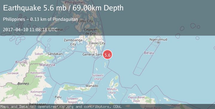
A 5.6 magnitude earthquake struck on PHILIPPINE ISLANDS REGION, at Mon, 10 Apr 2017 11:08:18 GMT. Depth: 69km. Reviewed by EMSC seismologists, this moderate quake occurred at a magnitude type of mb.
Magnitude
5.6
mb
Source
EMSC
Intensity
-
Agency Reports
1 Sources| Source | Magnitude | Depth | Time |
|---|---|---|---|
| EMSCPrimary | 5.6 | 60 km | 8 years ago |
Earthquake Details
AutomaticEvent IDemsc_EMSC_20170410_0000049
Tsunami PotentialNo
Magnitude Typemb
Nearest Places
- Tanjung Dapapa65.4 km
- Desa Pulau Miangas66.3 km
- Kecamatan Miangas66.3 km
- Pulau Miangas66.3 km
- Miangas66.9 km
Comments
Join the discussion about this event.
Latest Earthquakes
1.6Mag
13 km ENE of Falls City, Texas
Time16 hours ago
Depth7.18 km
SourceUSGS (Automatic)
1.3Mag
5 km S of Cabazon, CA
Time16 hours ago
Depth5.80 km
SourceUSGS (Automatic)
2.1Mag
Antofagasta, Chile
Time16 hours ago
Depth131.23 km
SourceVYT (Automatic)
2.3Mag
Sulawesi, Indonesia
Time16 hours ago
Depth2.74 km
SourceBMKG
2.8Mag
Alaska Peninsula
Time16 hours ago
Depth71.17 km
SourceVYT (Automatic)
Nearby Earthquakes
3.0Mag
PHILIPPINE ISLANDS REGION
Time2 years ago
Depth63.00 km
SourcePIVS (Automatic)
5.0Mag
PHILIPPINE ISLANDS REGION
Time4 years ago
Depth60.00 km
SourceEMSC (Automatic)
3.0Mag
PHILIPPINE ISLANDS REGION
Time2 years ago
Depth122.00 km
SourcePIVS (Automatic)
5.6Mag
PHILIPPINE ISLANDS REGION
Time5 years ago
Depth60.00 km
SourceEMSC (Automatic)
5.3Mag
Philippine Islands Region
Time4 days ago
Depth10.00 km
SourceBMKG