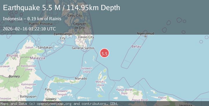
Earthquake North of Halmahera, Indonesia
Mon, 16 Feb 2026 01:22:10 GMT
Time3 days ago
Location
4.9729, 128.4134
Depth
114.9 KM
Event Summary
A 5.5 magnitude earthquake struck on North of Halmahera, Indonesia, at Mon, 16 Feb 2026 01:22:10 GMT. Depth: 114.947823km. Reviewed by BMKG seismologists, this moderate quake occurred at a magnitude type of M.
Magnitude
5.5
M
Source
BMKG
Intensity
-
Agency Reports
1 Sources| Source | Magnitude | Depth | Time |
|---|---|---|---|
| BMKGPrimary | 5.5 | 115 km | 3 days ago |
Earthquake Details
ManualEvent IDbmg2026dgdw
Tsunami PotentialNo
Magnitude TypeM
Nearest Places
- Snellius Ridge117.5 km
- Desa Marampit Timur143.0 km
- Pulau Intata143.9 km
- Desa Marampit144.2 km
- Desa Kakorotan144.2 km
Comments
Join the discussion about this event.
Latest Earthquakes
1.5Mag
British Columbia, Canada
Time14 hours ago
Depth25.88 km
SourceVYT (Automatic)
2.9Mag
Antofagasta, Chile
Time14 hours ago
Depth109.25 km
SourceVYT (Automatic)
1.9Mag
Andreanof Islands, Aleutian Islands, Alaska
Time14 hours ago
Depth0.85 km
SourceVYT (Automatic)
0.9Mag
Washington
Time14 hours ago
Depth0.00 km
SourceVYT (Automatic)
2.7Mag
western Texas
Time14 hours ago
Depth1.34 km
SourceVYT (Automatic)
Nearby Earthquakes
4.0Mag
NORTH OF HALMAHERA, INDONESIA
Time3 years ago
Depth10.00 km
SourceDJA (Automatic)
5.2Mag
north of Halmahera, Indonesia
Time6 days ago
Depth10.00 km
SourceVYT (Automatic)
4.0Mag
NORTH OF HALMAHERA, INDONESIA
Time5 months ago
Depth10.00 km
SourceBMKG (Automatic)
3.8Mag
North of Halmahera, Indonesia
Time6 days ago
Depth10.00 km
SourceBMKG
5.1Mag
north of Halmahera, Indonesia
Time6 days ago
Depth10.00 km
SourceVYT (Automatic)